Monday May 14th
Sarah woke up at 6:30 in the Miners Inn and got coffee, then Dave and I got up in time for the early half of the continental breakfast. I think every hotel in CA adheres to the same definition of a continental breakfast: cereal and milk, fruit pastries, toast and jelly packets, a few bagels if you’re lucky (with cream cheese packets), a waffle station, bananas and oranges, coffee/tea, apple and orange juice, and hard-boiled eggs. This was the menu for most breakfasts throughout the trip. We ate enough to be satisfied, while strategizing about the Tioga Road.We’d been hoping that the Tioga Road in the North part of Yosemite, running along the ridge between Yosemite Valley itself and the Grand Canyon of the Tuolomne River, would be open for our visit. It sometimes doesn’t open until late June and rarely is open in mid-May, but the snowpack this year was less than normal and the road had opened about a week before we got there. That meant that we could escape the crowds in the Valley and go on some of the most beautiful hikes in the park.
I’d printed out some possibilities and we worked out the itinerary over breakfast: that we wouldn’t stop that morning until we achieved Olmsted Point and would then continue on to the Gaylor Lakes Trail at Yosemite’s East entrance and then maybe swing by Tenaya Lake on the way back if we had time. We were concerned about how long the Gaylor Lakes Trail would take us and how we’d respond to the altitude, but we were psyched to give it a shot!
Loaded up with some difficulty (we weren’t accustomed to this yet and the ice bag, as mentioned, had developed a penchant to lose its cool and its ice, which required some coddling) as the day started to get seriously warm in Mariposa. We really wanted to pick up a device so we could play the MP3 player over the radio, or at least pick up some more CDs, but all candidate stores were closed when we detoured through town.
Oh well, we started back uphill towards Briceburg through the winding valleys and the ghost trees (our term for the Foothill Pines), past the rock slide (the couple at the front of the 15-minute line were out of their car and peering over the edge when the light turned green … shame on them!), and up the Merced River until we were in Yosemite proper at around 9:30. We had to stop soon after that to watch the beautiful river and let our minds soak in the fact that we were back in that incredible place on another brilliant blue day. Then we hightailed it outta there, up and up the hill, turning back onto route 120 at the entrance to the Valley, winding back up through the tunnels and past the thick lupines to Crane Flat, and then turning right onto the Tioga Road.
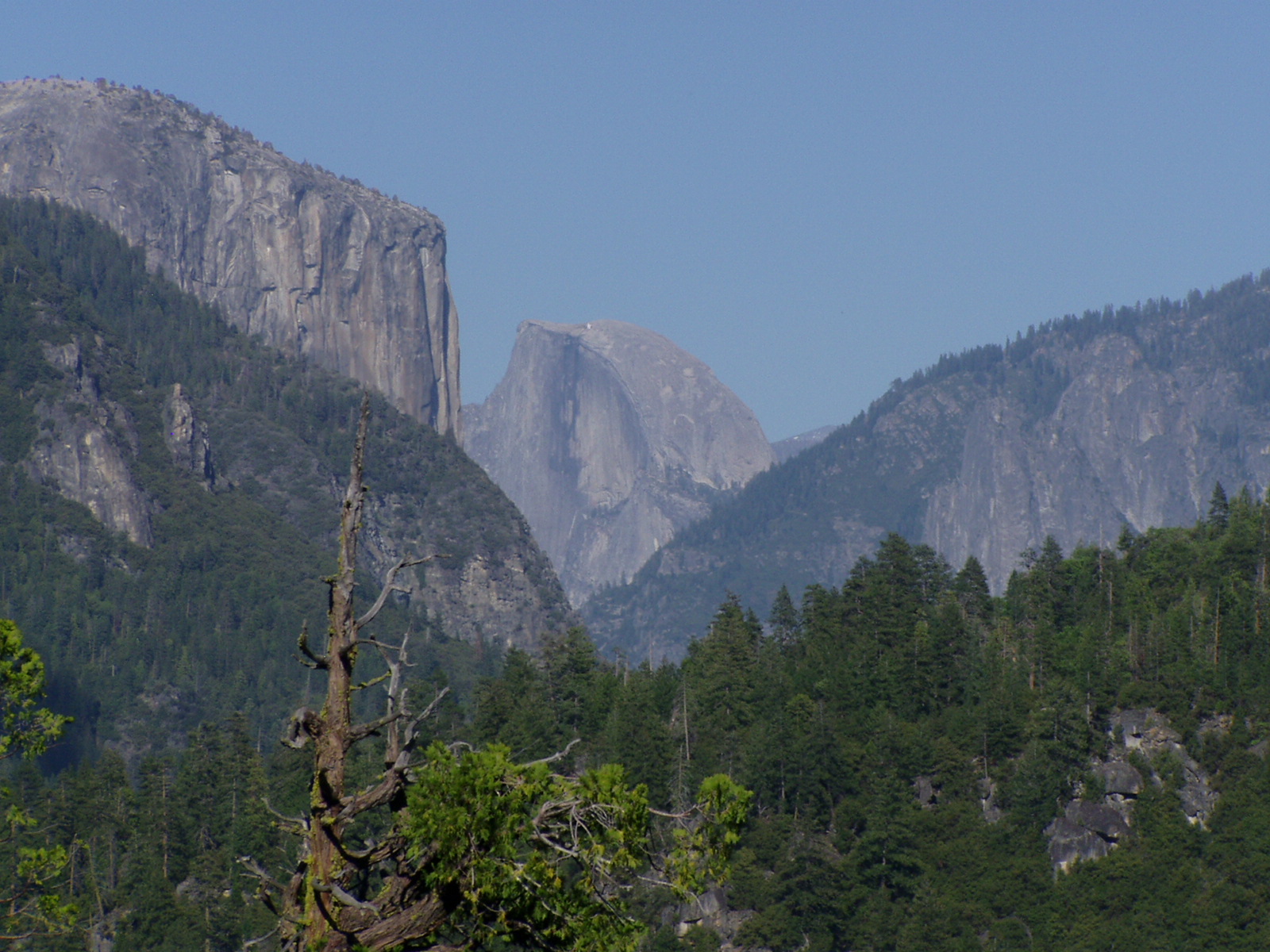
We roared past the already-crowded parking lot for the Tuolomne Grove of Giant Sequoias at the start of the road and then watched things thin out as we powered up, and up some more, winding past the closed campgrounds. We made it up to a high ridge and saw some incredible vistas off to our left as we approached Olmsted Point (yes, named after the famous architect Frederick Law Olmsted). We pulled into the parking lot at 10:37 and jumped out of the car in a state of extreme excitement.
Time to gush about Yosemite again: we had passed some breathtaking spots in the Merced valley and just now on the way up towards the northern part of the park, and they had featured some of the most astonishing sights you can see. But Olmsted Point has views you just cannot believe. As the hiking guide says, “Q: Should I go to Olmsted Point? A: Take this quiz: is the Tioga Road open?” The point is that if you don’t go see that place when you have the chance, you will be missing one the most scenic spots I’ve ever been to, especially on a clear, see-forever day like we had. The blues were iridescent, the grays were intense, the greens were soft, and the whites were mystical. If you go to Yosemite you certainly have to see El Capitan and Half Dome from the Valley, but then you must immediately go to Olmsted Point and be amazed.

There were 10 cars or so in the parking turnout when we arrived, and most of the people in them just stayed in the lot and gawked at Half Dome from there. But there was a short trail you could climb down and it let out onto a bare rock face from which you got even better views, including an angle of the massive Clouds Rest that almost put El Capitan to shame (it’s a 5000 foot drop as compared to 3500 feet, but who’s counting?). And if you turned towards the North you could see the deep blue slash of Tenaya Lake in the next valley and the snow-capped mountains of the Sierra parading North behind it.

I climbed up to the top of the granite face to see an old pine that was hanging on there in the wind, and suddenly a Sooty Grouse popped out around the corner of a rock and tried to communicate with me. The stiff southerly wind was ruffling his feathers so much you could see his red flesh underneath. He hopped onto a rock and then did a few slow wing-beats up into the tree, where he continued to try to talk to me, though he didn’t seem to hold much hope that I’d respond in kind. Dave and Sarah and I wandered up and up the rock face and were staggered by the beauty and the sudden solitude, but when we all gathered at the top of the slope we saw that the crowd was right behind us and it was time to leave. We walked back down and found the trail to the parking lot, which was by now almost half full of cars. Boy, just that place alone was well worth all the traveling we’d done.

As mentioned, the first few days of the trip seemed to be plagued with little things going wrong, though even then we had to admit that they were small: that morning we couldn't get the tunes we wanted, it took us forever to get to where we wanted to go (we later realized that this was true wherever you went in California, even if you hurried), and the oppressive crowds followed after us wherever we went. Then some more small things went wrong. It was already almost lunchtime when we left Olmstead Point, our first stop of a day in which we hoped to squeeze in three. We skirted around lovely Tenaya Lake and then motored up past several bald domes to breathtaking Tuolomne Meadows itself. Sarah was determined to stop at the Tuolomne Meadows Visitor Center (VC) and get a ranger’s opinion as to how difficult the Gaylor Lakes trail would be … but we saw no sign for the VC and before we knew it we must have passed it. As it turns out, it wasn’t yet open for the year. So we kept on going past Dana Meadows and then up and up again towards the trailhead for Gaylor Lakes just at the East Entrance at 10,000 feet, where we were foiled again!

We got out in the small parking lot just before the Entrance/Exit and looked around and breathed the air. Each of us checked out the bathroom and then the trailhead separately, and each of us reached the conclusion that we just couldn’t do it. I haven’t mentioned the snow drifts up the Tioga Road, but they had started popping up in the shadows and ravines at 7000 feet, had gotten pretty thick by the time we reached 8000 feet, and then by 9000 feet we saw graphically why the road had been closed until recently. At 10,000 feet the snow was definitely melting and most paved areas were clear of it already, but some places still had up to three feet and the trailhead featured some of the thickest drifts, mixed up with places where the snow had melted but were a soggy, muddy, sink-to-your-shins mess. Added to that was the fact that we were having a very hard time with the altitude and would have had to stop and pant every 50 feet on the trail … and it was going uphill so it would only get worse! Two groups of dressed-to-the-nines-in hiking gear adventurers showed up at the trailhead at about the same time we did and both of those groups tried the trail, but then turned back after a few minutes. The Gaylor Lakes trail was just not ready for hikers, nor we for it.
Oh well, the parking lot emptied out and we amazingly had some solitude as we made peanut butter lunch on Vicky’s trunk, sat on the bear box (more about this later) and ate sandwiches and oranges, did some prospecting for gold in the peremptory streams, gaggled at the above-timber-line mountains towering over us, and took pictures of the funny warning signs on the heavy equipment that was parked there to repair winter’s damage. We studied the map hard, looking for what our second choice of a Tioga Pass hike would be, and settled on the trail around Tenaya Lake. Finished with lunch (the wind caused Sarah’s sandwich to attack her), saddled up again, and headed back for the Tuolomne area where we were determined to get some information!
This time we saw a small sign directing us to the Wilderness Center (for back-country permits, etc.), which was the only open place at Tuolomne Meadows and was serving as a temporary VC. We went in and had a great talk with the rangers there, picking up lots of good knowledge and advice and a fantastic guide book (“The Laws Field Guide to the Sierra Nevada,” California Academy of Sciences). One ranger warned us that yes, we could attempt to walk around Tenaya Lake and the East end would probably be better than the West end (the end it drained from), but she doubted we’d be able to make it very far because of the high water.
As it turned out, she was very right. We parked with a couple of other cars in the large lot at the East end of Tenaya Lake but could barely make it to the beach because of the high water, and when we got there the beach itself was just an island of dry dirt. The water surrounded the picnic tables and the signage there. The lake was stunning … though scarily over-full, like a crystal tumbler split open … and we doggedly tried to follow the trail around it. But then the largest small annoyance of the day happened when I tried to cross a stream on some seemingly sound branches (Sarah and Dave were egging me on), and tumbled into the water when one collapsed. Not that cold after all as the day was very sunny and we could easily get out of the wind there, and I had some dry clothes back in the car, but still an embarrassment and quite a disappointment. Was there anywhere we could hike??

OK it was time for plan C, though what that was we hadn’t a clue. We got back in the car and drove up out of Tenaya Canyon, passing the crowded Lembert Dome parking area where most of the people who made it out there had apparently gathered, crossing back over the ridge of Olmsted Point, and pulling over a few miles later at Porcupine Flat. There was a closed campground here, no other cars, and a lovely trail switchbacking down the hillside that we followed among the pines and rocks. This was a fine hike, though not a loop, and we ended up on a shoulder of the massive slope watching a stream emerge from the mounds of shaded snow, among the strong shadows and lilting birdsong. Though we then had to climb back up the hill, this was another fine interlude for us. We needed to get out of the car and do something and this short hike was it. We would have gone further but we didn’t want to get too far downhill for fear of having a tough time coming back up and the trail we were on kind of petered out anyway.

Time remained for another hike and we kept on trying to find a nice trailhead as we meandered back up the Tioga Road. The first one we turned off for was at the end of a closed and snow-packed road and was another non-starter, but then we pulled over at the Lukens Lake trail and had another great short hike, past thick pines, suddenly bare hillsides, hidden swamps, and around great undisturbed patches of snow. If we’d kept going on this trail around overflowing Lukens Lake (if we’d been able to!) we would have made it to the Pate Valley of the Tuolomne, but we were feeling kind of full by then anyway.
Actually, I was feeling sick and dizzy even though we were having a great time! We were still up around 9000 feet and I think the elevation was just getting to me, giving me a headache and an upset stomach. We got back in the car and traveled precipitously downhill, back to Crane Flat and then back into Yosemite Valley through the tunnels, stopping for some lupine pix and some valley views. Sarah was bound to get to a VC, but I was feeling even worse in the Valley, probably because of the sudden change in elevation. And the crowds down there were worse than ever! We parked the car and found our way to their huge store (where I found exactly the hat I wanted), but we would have had to struggle past the cars, the busses, and the people for another half mile to make it to the VC. So we turned around and had a short snack break when we returned to the parking lot, with some quick peeks at Yosemite Falls and Half Dome through the trees.

We finally hit the dusty trail at around 6:00 and again left most of the traffic behind when we turned Southeast on route 140. We tumbled down the incredible Merced and exited out the Arch Rock Entrance for the last time on this trip. We’d seen Yosemite back in ’86 and been amazed by it, but that was our first time out of the Eastern Time Zone and we had nothing to place it with. Since then I’ve seen many beautiful places like the Grand Canyon, Acadia NP, Monument Valley, Arches NP, Yellowstone, Natural Bridges National Monument (NM), and what to my mind topped them all (if barely), Zion NP. So we had plenty of perspective this time, and I have to say that now Yosemite is the place I’d put first on my list of must-be-experienced places in the world. Not only the sights, but the smells, the colors, the crispness of the air, and the slant of the sun among the tall pines, on the ridges, and in the Valley all combine to put it a bit above … though any of the places I mention (and some we saw later in the trip) are up there too. The crowds can be a large drawback, but you’ve got to see Yosemite NP.
Back down into the foothills and away from the tumbling Merced, back to Mariposa at a bit after 7:00 where the stores that might have music were still closed (and showed no signs of ever having been open), as with the funky saloon that might have been fun. We ate dinner at a little Mexican restaurant in town where they were very friendly and had some great dishes, but had warm beer and not much of an idea what went into a vegetarian burrito. Sarah got a shrimp fajita dish which she loved and Dave had a “Melton bowl” that looked delicious. Made it back to the Miners Inn eventually and didn’t last long before we were all in bad and sound asleep.


No comments:
Post a Comment