Monday, October 22, 2018

Elizabeth Cook At the Bull Run

After dropping Dave in Quincy, drove out to the Bull Run for yet another fine concert on Sunday night, October 22.  This was Elizabeth Cook, and we hadn’t seen her since a couple of virtual decades in her career ago, since she was performing in a rock band with her husband.  She’s since divorced, etc. and was actually playing solo acoustic, which turned out to be excellent!

The big surprise when we got to Table 73 was that Star (and new husband) was there, an old friend from a couple of jobs ago.  Our table soon filled up but in all the room was just a little over half full.

Caleb Caudle opened with an absolutely incredible guitar, an old Gibson hollow-body walnut electric.  It sounded amazing and his voice complimented it as well.  His songs had some great, mellow hooks in them and he was way above average for an opening act on a slow Sunday.  He did mostly originals but included a Leon Russell cover and commented that “Liz” had told him that if he just went all white at once he’d look exactly like Leon Russell.  Couldn’t get that image out of my mind, she was right!

Then “Liz” came on, on the arm of her guitar tech, probably so she wouldn’t trip over all the wires in the dark, and wearing a rabbit-fur coat and studded pink boots.  She opened with the chestnut, Old Flames Can’t Hold a Candle To You, and did songs from all over the “Americana” portion of her career.

El Camino wasn’t rocking like it did when she did it electric, but she did a great Rock and Roll Man solo acoustic, and covered a number of songs from Welder and Exodus Of Venus.  She also did a bunch she hadn’t recorded yet and was working out on us, a couple of them still needing some work and a couple just about done.  She says she’s going into the studio soon and from the sound of these new songs, I’m going to like the record.

It was a short set of short songs on a Sunday, but her wise-cracking and her stories were as good as ever.  One of her new songs (Half Hanged Mary) may have some accuracy (it came from a Margaret Atwood poem) but she accompanies it with much nonsense (“Imagine having a Daddy named Increase … sounds like an asshole”).  And it appears her Mommy and Daddy used to play in a band with Florida Man!

One of her best lines was (r.e. her and Todd Snider), “We did *not* puke in the garbage cans!”  And she encored with Sometimes It Takes Balls To Be a Woman and then was off to her next gig.  She’s an excellent songwriter and performer, and I hope she’s still got a long career in front of her.

Monday, October 8, 2018

Seven and a Half States

Ack!  Woke up on Sunday the 7th and it was the last day of our excellent vacation.  We'd had a great time and realized we'd been kind of pushing the envelope, as is evident in the day we just experienced in Washington, in which we saw 16 things, some of them requiring a lot of inspection.  So we'd discussed taking it easier on our last day.

It was a last-minute off-the-wall kind of thing, but we realized seeing Theodore Roosevelt Island would be just what the doctor ordered.  We had to get SarahP and Jim to Dulles in the middle of the afternoon, and SarahE and I hoped to get as far North as possible after that, perhaps all the way home to Massachusetts.  We'd considered going back to the Mall and trying to find a parking space downtown, or leaving the car in its hotel parking lot and taking the Metro somewhere, then coming back to the hotel and getting the car in early afternoon.  But both seemed ambitious and possibly anxiety-inducing, which we did not want on our last day.  When we looked at the map we realized the island was right there, and it made a lot of sense to just have a mellow urban-park experience and have plenty of time to get out to Dulles without rushing.

I'd never been to Theodore Roosevelt Island, but had seen it many times, driving over the Theodore Roosevelt Bridge and from the Georgetown side.  Supposedly there was a family expedition there once, but I must have been out of town.  The first challenge though, was how to get there!?!  On Saturday Google Maps had told me to do some fancy footwork on Arlington parkways and I could approach the parking lot that way, but on Sunday morning it told me that because of street closings (more work on the Arlington Memorial Bridge) and the Army 10 Miler, I should go over the Roosevelt Bridge into Foggy Bottom, pull a U-turn at 20th St, and go back over the Bridge to the G.W. Parkway North.

Breakfast first.  All four of us went over to Ledo's Pizza and had the standard diner breakfast, that we had to wait a long, long time for.  There was only one staff person there and she had to take orders, cook, do dishes, and collect money at the same time, which was taking her forever because the place was suddenly very popular that morning.  Fortunately, she didn't yell at us and we decided that if we were going to have a mellow day, maybe a strung-out breakfast was part of the deal.  Anyway, Jim and I exited early and had the packing just about done by the time Sarah and Sarah returned.

Bumped the heavy suitcases downstairs and loaded up the car for the last time on this trip, and slowly pulled out of our coveted spot at the hotel.  Just as with The George Washington Grand, this hotel had advertised free on-site parking for guests but in reality had a parking lot that was nowhere near big enough to host all the guest cars.  We had barely snagged a spot when we pulled in on Friday and were loath to leave it.  But farewell to the Red Lion, farewell to Dark Star Park soon after that, and then we miraculously followed the convoluted path Google Maps had told me about, dashing into DC and back out, and then a few minutes later grabbing a spot at the busy public parking lot serving the Island and other recreational sites along the Potomac's Western side.


Roosevelt Island is in the middle of the Potomac, not very far at all from the center of the city.  It has a good number of trails, and most of them radiate from the Roosevelt Memorial itself, which we weren't interested in.  Instead we decided quickly to go counter-clockwise, as far from the vortex at the center of the Island as we could.  At first, this was a little crowded and there were signs telling us that we did *not* want to go on the Swamp Trail as it was a mass of mud from recent floods.  But after we looped under the Bridge we decided to risk it and took that right turn, towards the Swamp Trail, and we had a delightful, pretty isolated walk for the next couple of hours.


This ecosystem was perhaps more different from what a fresh-water estuary in New England would be (the Potomac in Washington fluctuates with the tides, but is entirely fresh water) than the Shenandoah Ridge had been from highlands in New England.  The reeds seemed similar but the edges of the island were populated with thick stands of swamp oaks, some growing to incredible thicknesses, though most of them were topped off by storms.  And the most distinctive thing was the pines, which were a variety we'd never seen before.


Birds rustled through the underbrush and sometimes flew out into the open.  At one observation deck in the middle of the swamp in the island's nether-land we saw a Blue Heron, an egret, and a large fresh-water snail.  At the North end of the island we made our way through the oak forest out to the muddy edge, right across the river from what used to be the Port of Georgetown.  It now featured college boathouses, sheltering under the Francis Scott Key Bridge, probably for Georgetown University and GWU.  The river was full of kayaks.


Coming around the head of the island we saw some great, worn river rocks, and then suddenly a family of four white-tailed deer.  The last quarter of the trail was actually very, very muddy but we made it, and we all scraped off our boots before tramping back over the pedestrian bridge to the parking lot.


A great last hike, a natural experience though we were in the middle of the city!  Our timing was perfect and we were right where we expected to be when we expected to be.  Scraped off some last mud, loaded ourselves up, and then headed out to Reston Virginia.  The traffic had already gotten intense and though we could have taken the George Washington Parkway all the way up the river to the Beltway and gotten out to the Dulles Access Road that way, Google Maps had a better idea and had us go cross-country through Arlington.  I'm sure it knew what it was doing because the Washington Beltway never seems to not be in a state of gridlock.


Reston is now a pretty big town, but was just a small planned community back in the 70s, leading to Dulles and the mysterious CIA enclaves out in the horse farms of Northern Virginia.  Everything there is built up at this point and well signed, and they're building the Metro out to Dulles.  SarahE had found a promising-looking restaurant on a lake out that way ... we wanted a nice place on the way to the airport.

We pulled into a mall parking lot and spied the Cafesano we were looking for, a relatively small spot in the sprawling mall.  The day had turned as hot as any day we'd experienced on our trip, and the sun was bright in a cloudless sky.  We went in and ordered at the counter, but quickly decided not to eat on their patio since the sun was burning down and the only spots in the shade were taken.  But we had a fine meal inside, and treasured the moment of a last lunch.  I had a chicken pesto panini, which was excellent, and SarahE had a chicken kabob.  We toured the "lake" for a bit afterwards, but it was kind of a joke.


We still had plenty of time, but had a longer road than expected to go out to Dulles.  The Dulles Access Road (a.k.a. Route 267) is a very strange superhighway.  It's got an inner section that apparently only let you enter or exit in Washington and in Dulles back when it was mainly a CIA conduit.  That center of the highway is now what you're directed to if you're not going locally.  It's paralleled on both sides by another part of the road, which allows local access and charges tolls, though the center doesn't.

Anyway, saw some of those distinctive airport buildings after a bit and the typical road in, with long lists of airlines, confusing departure and arrivals signs, and cars rushing by.  The curb at the terminal that hosted British Airways was a chaos of cars pulling up in the middle of nowhere, busses and limos, and cops whistling at everybody and threatening tickets if you stopped for longer than 10 seconds.  Just like an airport!


We were able to get close to the curb and get out Sarah and Jim's suitcases.  Very sad to hug goodbye after such a wonderful trip.  We'd traveled together before and been delighted at how compatible we were.  I was afraid that as we'd gotten older we might have drifted away from this a bit, but it turned out that we'd possibly gotten more compatible as traveling companions.  Or at least we were able to communicate well, to sense each other's moods and inclinations, and be willing to adapt to each other.  It may have helped not having young children along, not that our children are not delightful ... we would have loved to have them along, but the group of just us four was perfect for the kinds of decisions you need to make when traveling.

Waved goodbye and promised to be in touch, and then Sarah and I got on the long road.  It was 2:45 when we pulled away, and we had six more states to get to that day.  We'd already been to the half (the District of Columbia) and Virginia.  Next up was Maryland, Delaware, New Jersey, New York, Connecticut, and Massachusetts.  Google told us cheerfully that we'd make it back in 7:44, but we knew that was a too-rosy picture and that this figure would increase very soon.  And it did, Google freaking out at traffic on the Beltway and then leading us around through Northern Fairfax County before we got on and crawled up into Maryland.  Traffic was thick but moving, we were going as fast as we could in the left lane, and we were determined to make it back ... no more cheap hotels for us!


I'll spare the details of that long trip, except for a few highlights.  At one point in Northern Maryland, approaching the bridge over the Susquehanna, traffic went from 80 to 0 in a few short yards.  We lost some tread on the tires there (the ABS worked fine) and I was hugging the center divider so the car behind us didn't crash into us ... he had to weave into the other lane.  In Delaware we stopped for gas and to get sandwiches that we'd eat for dinner somewhere. In Northern New Jersey they announced that there were suddenly eight crashes in the George Washington Bridge area.  The option is to go over to the Garden State Parkway but there were crashes on the Southern bit of that too, so Google led us through some side roads (Route 3 in Rutherford and up Route 17), but when we got to the Garden State they had had more crashes and we crawled for the next hour up out of NJ and over the Tappan Zee.  At least we could eat our sandwiches while we crawled!  We had another almost-accident on the Saw Mill Parkway in New York, I still can't believe that these cars cut us off at 80 on a twisting Parkway and we didn't hit them.  And then there were three separate lane drops for (needed) construction in Western Connecticut that led to long delays.

Somehow we got back to Massachusetts and the Pike and though I was definitely tired I felt at that point that I could make it home.  I drove all vacation.  We finally got back to 495, back to 128, back to Winn Street, and back home, pulling into the driveway at a little before midnight.  In all, the trip from Dulles took just over nine hours, though (as Sarah said) 24 of them were spent in New Jersey.  Didn't unpack the car that night, but read a bit and had a snack so we could calm down from the drive, then had a long sleep in my own bed.

This was a distinctive vacation.  I'd wanted to take a trip to see Shenandoah, perhaps other parts of Virginia and Maryland, and DC for a long time, and was excited that it finally came to pass.  Our trip was shaded by many spectres, political, cultural, and medical, and was very strange because of that.  This was not a care-free week in the woods.  But we had some of the best times in recent memory in the woods and in the city and even on the highway, and it was wonderful to share these experiences with Sally and Jim!


Sunday, October 7, 2018

Lots Of DC Examined

SarahP and I had lived just outside of DC in our teens and early 20s and then had gravitated away to school, London, and Boston.  The rest of our family moved away from there by the end of the 70s.  It's hard to believe that I haven't been there since, after the (admittedly short) period of the city being central to my experience.

Both of us had Summer/vacation jobs at various places in the city, and our family lived in three different houses in Bethesda and Cabin John.  When planning what to see, we (or at least I) was tempted to see a bit of where we used to live and work.  But I realized that it's very likely this would have been disappointing.  I hadn't been there for over 40 years, and the ghosts I would have been looking for are long gone.

And when I looked for a hotel, thinking that there might be one close to Bethesda, I found the pickings in Arlington were actually by far the best.  And so my feeling was that we should forget trying to capture the past, that we should stay in Arlington, walk over the Memorial Bridge onto the Mall, and see stuff around the Mall with our modern eyes until we dropped.  There's more stuff there than you could see in a week, including a lot of stuff that hadn't been there 40 years ago when we were young!

Funny to call something around Washington "the Memorial" this or that, since the place is chock full of memorials.  The bridge we were destined to cross is officially called the Arlington Memorial Bridge, but Washington is chock full of nicknames and so I'll try to use the canonical names here.  And I have to preface that day by again saying that was another dread full experience.  Not "dreadful" ... we had a wonderful time, and the day was full of lovely, moving sights and personal interactions.  But the feeling of dread associated with the current crisis in our government was thick.  I always found Washington to be a straight-laced place, with people more concerned with convention than freedom.  I had lived there back in the Vietnam War days when every limousine, every police escort, and every collection of military suits represented the bad guys.  And this was the situation again.  Every time a helicopter took off from the White House or a street was suddenly blocked off, the feeling of dread was exacerbated.

 But anyway, time to wake up at the Red Lion, do my morning routine, and go to breakfast!  SarahP and Jim had gotten some breakfast yogurts at the Safeway yesterday, but SarahE and I walked the few yards over to the pizza place in part of the hotel, Ledo's, where they offered a typical "diner" breakfast.  I had the vegeterian omelet [sic].

Didn't need to pack up and load the car that morning and we knew what we were going to do.  The four of us were soon out the door and traversing the pedestrian walkway over Arlington Boulevard in the thick mist.  Only a few blocks on city streets and then we were in a National Park area, as we were for most of the day.

The first site we saw was the Marine Corps War Memorial, also known as the Iwo Jima Memorial, just South of our hotel.  I'm very familiar with the image the memorial is centered on, and have always considered it a little unreal.  In fact, the iconic picture was staged, though that should maybe be classed as an authenticity vs. sincerity issue.

I should have looked at the sculpture more critically, but instead my attention was taken by all the place names around it.  These were places where U.S. Marines had ... what?  Been dispatched to?  Invaded?  Died in?  Well, anyway, it was a list of conflicts the Marines had been involved in and it was amazingly long.  There was an unsettling number of entries in the list that we'd never heard of, though between the four of us we were very familiar with American history.  If you follow the link above you can see the list.  But it begged the question, are we supposed to be proud that our Marines have been involved in so many conflicts?  I'm sure some of them were justified, but for instance I know that the Grenada conflict in 1983 was nothing more than an embarrassing power grab.  How many of these incidents should we be proud of?  Oh well, this was the first of many memorials to violence that day.


The day was a little cooler than the recent average thankfully, and still a little overcast, though the sun would come out later.  The grass was damp beneath our feet and so we mostly stuck to walkways, though this was perhaps being overly conventional

Next up was the Netherlands Carillon, a gift from The Netherlands to the United States in gratitude for aid during and after World War II.  The Carillon was locked that morning and probably only opens for concerts.  We were lucky enough to hear it though, when it struck 10:00.  It's made of steel and features a lot of rust, but that's the medium they chose.  It's meant to be a "modern" sculpture, distinctive of Northern Europe, rather than another cookie-cutter Washington thing made out of marble, granite, or bronze.  And it's pretty successful in this, though not a compelling structure.  The best thing about it is its vantage point, looking West towards the National Mall across the Potomac, evocative of The Netherlands looking across the ocean at the U.S.  And they have musical-note-shaped flower beds that must be very colorful at the right time of year.


OK, next on our short walk down to the Memorial Bridge was skirting the Arlington National Cemetery.  We walked around the perimeter, between the Cemetery and the Jefferson Davis Parkway, and saw thousands of white tombstones in well maintained rows.  When we finally got to Memorial Avenue, we looked way down the straight road to our right and could see the grand entrance to the Cemetery and the Custis-Lee Mansion up on the hill (a.k.a. the Robert E. Lee Memorial ... we were having a hard time getting away from the Confederacy).  There was some kind of event going on there, people were pouring out of the Metro station and heading into the Cemetery.  We turned left...


... and we saw from a distance that the Memorial Bridge was closed!  I remembered that I had seen some signs about this on the parkways, but I hadn't had time to read them thoroughly.  We stopped a  young couple and asked if they knew if the Bridge was closed to pedestrians, or just to cars.  They were very nice to us tourists and the guy looked it up on his phone ... it was closed to everything that weekend.  This must have been the same people who closed the pool at the George Washington Grand on the night we were there and closed the Mexican restaurant in Elkton on Monday nights!

Oh well, we didn't have much choice; this meant that it was time to take the Metro.  Believe it or not, the Washington Metro hadn't even been started when I last lived there.  It's now been around for long enough to show signs of age in some spots, but is basically an effective transit system.  We all had to buy cards for $2 and put at least $8 on them.  We used them that morning and that evening (at $2 a ride) and so felt a little ripped off when we all had $4 left on our cards.  But this is par for the course these days and SarahE found a homeless center where we can contribute the leftover cards.


While the other three wrestled with the fare machines, I approached your typical mass transit employee who looks like she has much better stuff to do than answer your stupid-ass question.  I told her we were tourists and the Bridge was closed and we needed to know how to get to the Mall.  She seemed to take pity, for a second, and told me, "Take Largo to Smithsonian," which was all she needed to say and was a masterpiece of concision.

So that's what we did, after hanging out on the platform for about 10 minutes and checking out the maps and stuff there.  We realized that not every station stopped at by more than one of the six lines allowed transfer between the lines, but that some were hubs for a large number of lines.  Looked pretty well organized to me.  Next time I go to DC maybe I'll just ride around the Metro and eschew the depressing war memorials.


Whatever, we were going to see the depressing memorials that day (and hopefully some non-depressing stuff too), and it wasn't that long before we exited at Smithsonian, the seventh stop on the Blue Line.  By now the persistent overcast was pretty much gone and it had become a pleasant, mostly cloudy, breezy day, which was still too hot for me!  Our first stop was the Smithsonian Castle, where Dad worked for a short while, but just to visit the bathrooms.  From there we headed West toward the Capitol.


Just past the Castle and the Arts and Industries Building is the Hirshhorn Museum, which had been opened when I was living there.  And my spirit jumped when I saw their sculpture garden, on the Mall side of the Museum.  Don't know if I've ever been in the Museum itself, but I'd been to the sculpture garden several times and was delighted at the opportunity to do another quick visit there.  I strongly remembered a Henry Moore sculpture in the Garden, so vividly that I could almost feel its curves.  I hunted a bit and there it was, a beautiful organic thing in the middle of a lot of sterility.  I was home again in some way.


This was one of my favorite interludes of the day.  If you ever go to Washington, gentle reader, be sure to stop by the Hirshhorn Sculpture Garden.  Besides several Moore sculptures, it contains Rodin's Balzac and Burghers of Calais, as well as a sculpture of a tree (well, in fact it *was* a tree) contributed by Yoko Ono.  And a dancing rabbit.


We'd already seen several sites and we hadn't even arrived at the one we meant to see first yet!  The incredible number of choices among the Smithsonian Museums is pretty intimidating, but SarahE had expressed a strong opinion and I agreed wholeheartedly: we wanted to see the National Museum of the American Indian, just beyond the Air and Space Museum.


I hesitate to try to describe this museum ... go there!  We didn't see anywhere near all of it or spend as much time as we should have, seeing what we did.  It's surrounded by gardens meant to evoke the kinds of places Native Americans live/lived in; which is in fact, America.  The plaza and the shape of the building are meant to evoke the landscapes of the world, and the place of the world in the firmament.

When you get inside there's a grand concourse rising up to the 4th floor and you're supposed to take the elevator or stairs up to the top and work your way down.  Of course, in the way of museums 'n' stuff these days there's a film to see first to orient you, but we missed it by a minute or two and we just got started anyway.


Getting an overview of where native Americans lived, how they were organized into tribes/nations, and how the range of these nations changed is the information I most wanted to get, and this is difficult.  The answer is multi-dimensional, but there were exhibits that tried to give you parts of the answer; it could not be all done at once.  The exhibit I spent most of my time with was on treaties between American Indians and the [European] U.S. Government.  They addressed the concept of a treaty and how that resonated in both the Indian and European world, and how both parties were committed or not to the idea.  They displayed specific treaties, and they had displays on the geographies involved, the people involved, and how the treaties turned out.  Let me just say that the Europeans flooding the continent did not come off well in this exhibit, though the exhibit was always objective.  One of the treaties featured was the one Johnny Cash has memorialized in song, where George Washington betrayed the Senecas.

This exhibit of course concentrated on tribes located mainly within the borders of the United States, though others depicted Indian heritage throughout the Americas.  We all spent a lot of time at an exhibit of three-dimensional figures of animals from all over the Americas, some created a few hundred years ago and some very recently.  We also looked at a display case of toys and clothes created over a similar time span.  This was very much a living museum in that their mission included collecting contemporary artifacts as well as historic ones.


And this aesthetically and functionally  oriented artwork was incredible!  I had seen belts of wampum in the treaties exhibit that must have taken incredible technical skill to make, and these objets d'art generally combined that incredible skill in beadwork and wood-shaping with a simultaneous timelessness and immediacy of form.  This seal had not only just jumped out of the water in front of you, it had been doing that for time immemorial.


Wow, this was a great experience!  But we were weak with hunger by the time we'd just skimmed through half of the exhibits.  Luckily they had a great cafeteria downstairs, which was also an integral part of the museum.  They had food stations in it that concentrated on Native American dishes from particular regions, and though the prices were a little high that was fine with us.  SarahP and I went to the meso-American station and I got a fantastic bean salad, Sarah got a quinoa soup, and we shared a piece of cornbread.  SarahE got frybread and buffalo chili at a Southwestern Indian station ... and I got a Belgian beer.

Got a great table in their crowded cafeteria and we decided that as much as we wanted to stay here, we had to press on after lunch.  We had done a lot already and there was still plenty of time in the day, but we had to seize it!  SarahP and Jim wanted to get over to the Capitol and maybe around it to the Supreme Court and I was a little skeptical as to whether this would be worth the long walk, but as always our group decision was the right one.  We left NMAI (I had to drop a few bucks in their hopper, this is a fantastic museum and we need this kind of stuff), exited out a different way than we had come, and proceeded up to the Capitol.


The next Act in our trip to Washington was the most dread full.  This was the day that the Kavanaugh nomination was going to be voted on by the Senate, and analysis was showing that they had the votes.  We were headed right for the Senate chamber (Jim correctly identified the Senate's wing of the Capitol by the fact that it was flying the flag) and we could sense the evil fog emanating from the place, though this was probably just standard Washington humidity and that area has seen plenty of fog over the last 218 years.

The Capitol Reflecting Pool was empty, and we headed up toward the West lawn anyway, still a little unsure as to whether we'd go all the way around that huge building.  It was great fun to watch tourists from all over the world taking group pictures and selfies with the Capitol and the Mall in the background.  We took a few ourselves, both of us and them!  And then we pressed onward, around the Senate wing and up to the business side, where a large impromptu rally was in progress.


Groups of people were pressing up to the steps in the center of the building on that side, chanting.  Hundreds if not thousands of others backed them up, and we moved to the center.  We were expressing our rights and our indignation.  Poll after poll showed that a majority of the American people were opposed to Kavanaugh's being seated on the Supreme Court, and it was a blow to our concept of the people being in charge of the government for it to be about to happen anyway, to say the least.  And we were right there, staring at the demonstrators, the building where it was happening, and the blameless Capitol police who saw this every day and considered it part of their job.

And there was a group of demonstrators from the Holton-Arms School, wearing t-shirts proclaiming this.  SarahP had graduated from Holton-Arms about 10 years before one of the events we were all indignant about, where Kavanaugh sexually assaulted a Holton-Arms student in their teenage years.  The women were delighted to meet an alumna as successful and exotic as Sarah, and the representative oldest woman there admitted that this alumna pre-dated her significantly.  They were out of t-shirts but had us all sign their placard and gave Sarah follow-up information.


There was another, perhaps bigger rally going on on the Hill simultaneously, over at the Supreme Court.  We headed over there around the long line of people waiting to get in to the Capitol and sit in the galleries of the Senate, as is our right.  We got as far as the edge of 1st St. NE, near where it meets Maryland Ave.  There were groups of people on the large steps of the Supreme Court building; probably they'd gotten in for a tour and then stepped outside to watch the scene.  There was a police barrier between the steps and the crowd, where there was a real rally going on with speakers, though often drowned out by enthusiastic chants from elsewhere.  The passion in the crowd was palpable, as well as the evil smog that overhung it all.  And of course there were Trump/Kavanaugh supporters scattered about, though they were few and far between.  A group of teenagers on motorized scooters who were wearing Trump t-shirts broke out of the pack and headed downhill past us speedily, as we wended our way back to the Mall.


Oooh, have I mentioned the motorized scooters?  Major cities have been going out of their way recently to declare themselves bike-friendly.  In fact, the Red Lion Hotel had a rack of bikes that guests could take out for the day.  But there seems to be a subversive movement going on connected to this: motorized scooters.  Of course the problem with a bike is that you need to actually pedal it, and this can lead to you looking harried rather than cool.  Motorized scooters (electric) were all over the fucking place, clogging up the bike lanes and running people off sidewalks.  I didn't think this was cool.

Finally dropped down off the hill and back onto the Mall, though navigating many urban crossings was required.  Our next goal was to see the outside of the new National Museum of African American History & Culture, and then the White House.  The Mall was beginning to wear on us, this was a long walk.  But we'd warmed up for it in SNP.  It was a weekend admittedly, and right in the middle of the Fall school term; but even so there were an incredible number of people on the Mall.  The line to get in the National Museum of Natural History, which I'd hoped we'd have time for, stretched around the block.

The African American Museum looked impressive, taking up a massive block in the Mall, and featuring a gold frieze of natural shapes.  There was no way we could get in, though SarahP tried.  We would have had to have gotten tickets by email months ago.  But the lawn leading up to the White House was free, when we got that far.  We were still way South of it when we declared ourselves to be close enough, and we sat down for a good rest and some water.

There's been pressure on the NPS to close off areas around the White House, to suppress the ability of the people to demonstrate.  They had a large part of the Ellipse fenced off, like they were re-seeding it, but they weren't.  This meant people couldn't gather on the lawn to yell truths at Trump, though the people standing on the sidewalk along Pennsylvania Ave were doing what they could.


There were a few more things that were at the tops of our lists for things to see on the Mall, and SarahP proposed a plan for a loop that would allow it.  We started off due South and then followed the paved path a little West, curving past the Washington Monument, which is a tall sucker.  We saw a bit of the National World War II Memorial at the East end of the Reflecting Pool.  We didn't stop there, but I thought it very successful in looking like a monument from the 1940s, though it was built on the 1980s.

Where we were heading was the Martin Luther King Jr. Memorial, slightly off of the Mall, across Independence Ave.  Before we could get there we caught a glimpse of the District of Columbia War Memorial, and a glimpse was fine.


The King Memorial was inspiring and is in a beautiful setting, off the craziness of the Mall and bordering the Tidal Basin in West Potomac Park.  You enter it through a mountain of marble, evoking one of his most famous speeches.  On the other side is the slice of the mountain that he's symbolically removed, with a monumental statue of him emerging from the other side.  He's facing the Tidal Pool, but is not looking out, rather he's looking thoughtful and reflective, like he's considering his next speech.  His suit is stylized, with even waves of wrinkles.  But his hands and his face are human, belying the scale.


It was just then that phones all around us let us know: the Senate had just voted to confirm Kavanaugh.  This was an especially sad, emotional, moving moment.  We were standing there, staring at a monument to the underdog in our democracy, who had the moral virtue necessary to a true leader.  And we were hearing of another false leader advancing.  The backdrop of the statue was a long wall, bearing quotes from Dr. King.  One of my favorite quotes of his was there, and I found it particularly relevant: "The arc of the moral universe is long, but it bends toward justice."

Another incredibly moving experience, and there were a couple to go!  We cut back across Independence Ave and through the bit of woods by the Park Service stables over to about halfway down the Reflecting Pool, then turned to our left, towards perhaps the most meaningful monument I've ever seen, the Lincoln Memorial.


This end of the Mall was perhaps even more crowded than the other end had been.  Every one of the steeper and steeper sets of steps up from the Reflecting Pool was covered with people, and we had to weave back and forth to get up to the top.  We stopped several times on the way up and turned to take in the incredible view of the Washington Monument appearing more and more in the Reflecting Pool, and the Mall being revealed to us, with all the buildings, trees, and people on it getting smaller and smaller.


At the top of the steps the view is complete and you can see the Capitol on top of its hill in the distance.  Then you turn and the shadows part and there is Daniel Chester French's monumental statue of Lincoln, sitting in his chair and thinking deep thoughts.  His head turns to the side and his gaze is downwards, showing sadness mixed with resolve.  There are signs asking people to respect the quiet of the place, but it was filled with people gabbing in all languages, toddlers crying, and groups shouting at each other while they took pictures.


I walked over to the South cove of the memorial and read the Gettysburg Address, and studied the mural over it, showing an angel presiding over a scene of discord.  After that I went over to the other cove and read his second Inaugural Address, under a mural showing the same angel uniting the people.  The Lincoln Memorial was just as I remembered it from over 40 years ago, corny, overblown, mobbed with people, and incredibly moving.  There is hope for our union and our world, and words of truth will lead us there.


We ducked into the small gift shop to see how crowded it was.  There were some interesting looking books but we got out of there, assembled, and picked our way down the steps.  Only one more destination to go, the site that was at the top of my list of things to see, the Vietnam Veterans Memorial.


This was another memorial that had been built after I left Washington, and I'd wanted to see it for years.  It's also another memorial that I don't feel I can describe as well as I should.  You have to go see for yourself.  I'd read a lot about it and seen smaller replicas.  When we approached I felt I was ready for it, and it was perhaps less imposing than I expected at first.  It's in a corner of the Mall that gets a lot of auto traffic noise, and there's a lot of foot traffic down at that end too.  And the heart of the monument itself, the Wall, was packed with people tracing names, taking selfies, coddling toddlers, and doing all those things people do.


But then it strikes you, and I had to hurry out of the Wall area to see this more completely.  The memorial is not one artifact, or a monumental statue, it's an environment consisting of lawn, trees, people, baby carriages, a couple of movingly realistic bronze sculptures, and also the Wall and the people interacting with it, and the short lawn at the top of it, leading to a busy street.  I was alive during that war and I demonstrated against it on the Mall and saw it every day on the TV.  That was the meaning of this environment, to show the connection between our reality and the reality it was commemorating, and the mindless incomprehensibility of the war.


We'd recently seen marks left by the Civil War all over the countryside.  Perhaps people wounded physically or psychically by that war were able to go to the Lincoln Memorial and feel the same kind of depiction of their experience.

And that corner of the Mall is a little sunken, and you can look up the gradual slope and see the top half of the Washington Monument poking up above the horizon.  And way in the distance you can see the top half of the Capitol.  And you realize that not only is the Vietnam Veterans Memorial a whole environment with a message, the whole Mall and the whole world is part of that environment.  The Park Service tries to maintain the Mall as a homogeneous experience, and we had just traveled it from one end to the other.  Perhaps the United States was no more comprehensible after this experience, but we definitely felt closer to the complexity.

OMG, the others were as affected as I was and SarahP took a long time at the Wall.  We showed her the Vietnam Women's Memorial section after that, which is really part of the whole thing.  And then we tried to get away from there a bit and strategize about dinner.

It was SarahP's turn to pick a restaurant, and she wanted to find somewhere concentrating on vegetables.  Several possibilities popped up on SarahE's phone, and we decided to head up to the Beefsteak location on 22nd St.  One good thing about this was that it was right in the direction of the Metro stop we wanted to end up at.  It wasn't that far, but we walked very slowly up there, into the middle of the George Washington University campus.  Across Constitution Ave, up 21st St, diagonally up to 22nd St on Virginia Ave, and finally to the right block.  We found a statue of Pushkin on the way, as well as a little memorial to a liberated slave (Leonard A. Grimes) who'd moved to Boston.

Finally made it up to Beefsteak on I St (labeled "Eye St" so people don't get confused), and there was some debate over whether we really wanted to eat there or go to another restaurant.  But everything else in the neighborhood was very high priced, so we did eat there, getting some nice bowls (I got a "crunchy avocado" thing) which we ate at tables on the empty and quiet sidewalk.  We confused the heck out of them though.  They thought they were a hip venue for college students and when these elderly people came in and started expecting them to do advanced math, like to put four orders on one check, they were discombobulated to say the least.

Dragged down to the end of the block after that and dropped down into the Metro's Foggy Bottom stop.  It was just one stop across the river over to the Rosslyn neighborhood of Arlington and we were more than ready to get back to the hotel.  Two things happened when we got off of the train in Rosslyn though.  One was that we went up the longest escalator that has ever existed, or at least that I've been on.  Seriously, this thing must have been a mile.  SarahE reports that she was hallucinating on it, thinking when she looked up that we were moving vertically.  And the second thing was that when we got out of there we didn't know which way to turn and probably turned the wrong way and headed in the right direction, but were now on the wrong side of the looking glass and so were a little lost.

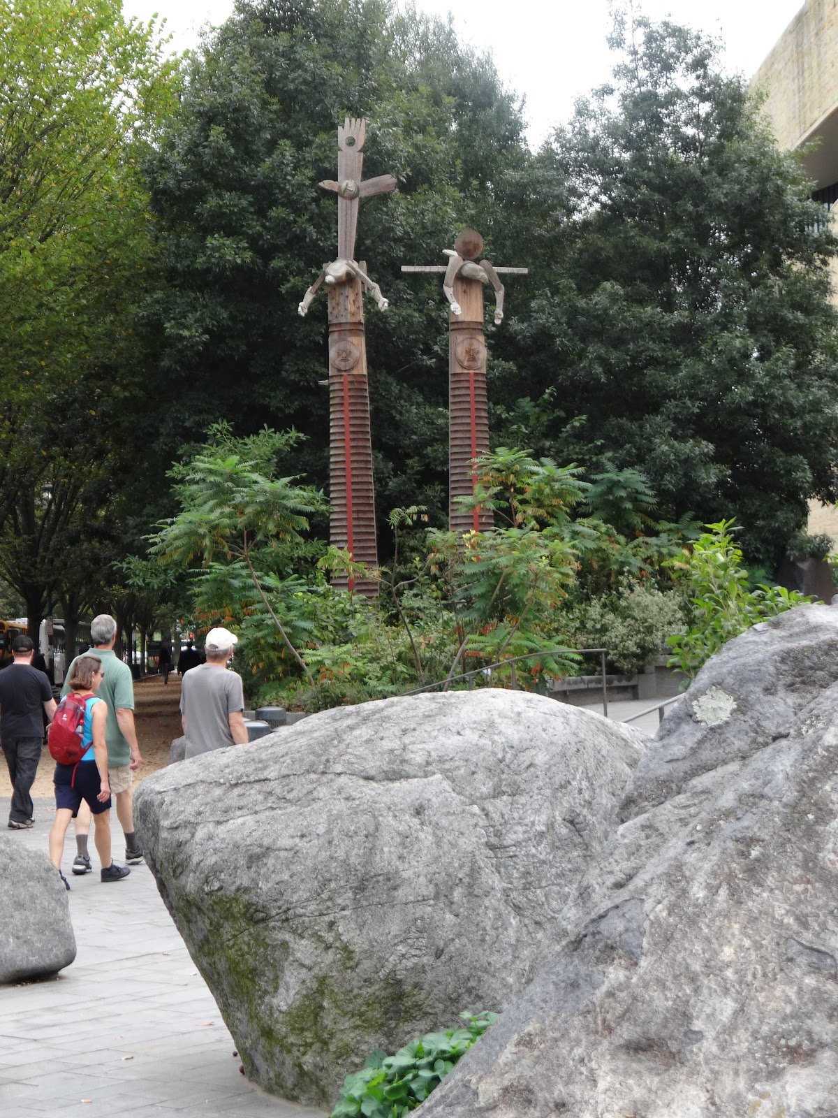
Luckily, several phones were deployed and we turned around and headed in the right(?) direction.  We were getting a bit confused again and then there it was, Dark Star Park!  I had seen on the map that there was a park right near us named after the epic Grateful Dead musical work.  Oh wait, it wasn't??  You mean, this was just synchronicity that when we were lost we found this sculpture garden pointing us the way home (or to the Red Lion at least)?  Whatever.  We frolicked in the park for just a bit and then headed back to the hotel.


Yay, we were finally back!  It had been a long, long day and we felt very good about what we'd achieved.  By my count we'd seen 16 things, as well as the GWU campus and the Metro.  And we'd had a couple of great meals and hadn't been arrested.

The Red Sox - Yankees Divisional Series came on, but the Red Sox fell behind early and I went to bed.  Past time after an exhausting day!


Saturday, October 6, 2018

Confluence of Everything

Woke up on Friday in a cloud.  It was actually cloudy outside and rained a little that morning, though the dreaded long Fall rain held off and it became another fabulous day.  I was also in a little bit of a psychic cloud, wondering where Sarah was (I hadn't heard her leave), dealing with the black bathroom, and finally finding my way down to the basement through two musty flights in search of the windowless breakfast room (after replenishing the cooler with ice).  Sarah and Jim were right in front of me (or ahead of me?) and we all helped ourselves to the typical cheap hotel breakfast.  No donut turds this time at least.

What is it about non-disposable stuff at hotel breakfasts?  We cringed to use styrofoam plates, thin plastic juice cups, flimsy forks and knives, and garbage plastic coffee cups (pretty bad coffee too).  But we got the requisite number of calories and some vitamins and then headed back up out of that dreary room.  Luckily there was a cute baby in a stroller to divert our attention.  There are tourists (and babies) everywhere!


SarahE still hadn't showed up, but she was in the room when I got up there and had been a little discombobulated herself.  It was a strange place, and the strangest thing was the print hanging above the only acceptable coffee-maker around, the Keurig near the musty elevators.  This was an example of displaced (or at least not understandable to us) allegiance to Confederate icons, and to militaristic music.  The print was bordered by images of artifacts of 19th century military/country life: a confederate hat, gloves, a simple home, a brace of pistols, a covered bridge perhaps.  It was captioned, "Onward Christian Soldiers."  And the main image was of three named Confederate generals accompanied by a fawning colonel, riding horseback but pausing at the top of a rise and all smiling at each other like they were the happiest, most confident people in the world.  One was Stonewall Jackson but I forget the other names.

I won't go on about the psychosis expressed by this picture, though I might.  Let me just say that romantic individualism is not well expressed by military uniforms, or portraits of a group of leaders.  People will disagree and that's fine, but I found the print strangely offensive.  Might make another great t-shirt!

But though the day had started off strangely, I was pretty excited about our plan.  We were going to see Harper's Ferry,which I'd heard a lot of good things about, and then end up in the metropolis of Washington that night.  Jim and I were delayed at the coffee-maker by one of those people who went on about how great Harper's Ferry was, though he got more and more of his facts wrong the more he spoke.  But as I say, this wasn't the place to discuss politics or call another person's "facts" into question.

Checked out, loaded up, and the day was actually beginning to look promising by the time we waved goodbye to the Ramada and Hangouts.  Back to Interstate 81 North to the same exit in Winchester that we had approached from the North back on Sunday, and East on Route 7, then North on Route 340 (the aforementioned main road through the valley) in Berryville.

This was another great time to see the countryside, in the Northwestern-most part of Virginia and the extreme Eastern-most part of West Virginia.  There were still some corn and soybean fields, but also some horse farms, some auto repair shops, and some groceries.  There were also lots of "lower middle-class" houses, as there had been in the Shenandoah Valley proper, one-story cinder-block structures with perfect, huge lawns.  There were a few scattered post offices and city halls, and lots and lots of churches, all Christian.  It was beautiful in its own way, expressing pride in communities and well-lived lives.

Harper's Ferry is a very small town at the confluence of the Shenandoah (which had joined with its South Fork by then) and Potomac Rivers, located in West Virginia with Maryland across the bluffs to the North and Virginia just over the cliffs to the South.  There's a National Historical Park there, but one of the wonderful things about it is its place in the geography of America, not just that it's been preserved.  We need to cherish crossroads like this, they tell the story of our land.

This was also the key location in John Brown's aborted slave rebellion, one of the key events presaging the Civil War.  But luckily we weren't swamped by history that day, it was all about seeing this great confluence of early America.

From Route 340 we could sense the crotch in the mountains ahead, and barely see the Shenandoah River off to our right.  We turned into the NHP parking lot and flashed the Senior Pass again to the happy Ranger.  Big parking lot there, this must be a high-attendance Park in the Summer.  We looked at the diorama in the VC, hit the comfort station, and strategized.

Harper's Ferry offers three main themes: historical, commercial, and natural.  I've mentioned the historical and natural, but the commercial is very important.  We stumbled on a graveyard commemorating the first (European) settler, Robert Harper, who saw the potential in the place but established a town of only 4 people.  Lewis and Clark later used it as their jumping-off place for their early-19th century expeditions.  The Chesapeake and Ohio Canal and the railroad were built up the Potomac from the Washington DC area in the mid-19th and that's when the town was at its height.  There was also a canal that extended up the Shenandoah, though I have no idea how far it got.  The C&O and the railroad continued up the Potomac and then jumped over to the Ohio in lower Pennsylvania and so opened up the West to early America.


We decided to hike it and go for the natural theme.  Unfortunately, Route 340 crossed the rivers right below where we were hiking and highway noise was omnipresent!  But this was a fine hike, down the bluff to the Shenandoah, down the floodplain of the river (where we saw a turtle), which featured the last mile of the same railroad we'd seen in Winchester last Sunday.  Where Route 340 crossed the trail we switchbacked to the North back up the bluff and joined the AT, which of course went through this important crossroads.


We followed the AT into town, past the old graveyard I mentioned, and stumbled on an Eastern box turtle that was trying to cross the trail as quickly as possible but was terrified by us.


The key feature here was Jefferson's Rock, which overlooked the confluence just a hundred yards or so before the trail dove downhill into the town.  We'd heard a lot about Jefferson lately, and were not impressed by another place named after him.  But I have to quote him at length here, as he expresses the wonder I try to express often in this blog:

"The passage of the Patowmac through the Blue Ridge is perhaps one of the most stupendous scenes in Nature. You stand on a very high point of land. On your right comes up the Shenandoah, having ranged along the foot of the mountain a hundred miles to seek a vent. On your left approaches the Patowmac in quest of a passage also. In the moment of their junction they rush together against the mountain, rend it asunder and pass off to the sea. The first glance of this scene hurries our senses into the opinion that this earth has been created in time, that the mountains were formed first, that the rivers began to flow afterwards, that in this place particularly they have been so dammed up by the Blue Ridge of mountains as to have formed an ocean which filled the whole valley; that, continuing to rise, they have at last broken over at this spot and have torn the mountain down from its summit to its base. The piles of rock on each hand, but particularly on the Shenandoah, the evident marks of their disruptions and avulsions from their beds by the most powerful agents in nature, corroborate the impression.

"But the distant finishing which nature has given the picture is of a very different character. It is a true contrast to the former. It is as placid and delightful as that is wild and tremendous. For the mountains being cloven asunder, she presents to your eye, through the cleft, a small catch of smooth blue horizon, at an infinite distance in that plain country, inviting you, as it were, from the riot and tumult roaring around to pass through the breach and participate in the calm below. Here the eye ultimately composes itself; and that way, too, the road happens actually to lead. You cross the Patowmac above the junction, pass along its side through the base of the mountain for three miles, the terrible precipice hanging in fragments over you, and within about 20 miles reach Frederictown and the fine country around that. This scene is worth a voyage across the Atlantic."


Well ok, this is what we saw and he describes it well.  The rivers came together in a powerful, majestic way, under the railroad bridge we (and the AT) walked along, and pointed East to Washington and the sea.  When we crossed the bridge to the Maryland side, we climbed down to see the (well preserved) ruins of the C&O Canal and Lock 33 as it rose uphill towards Ohio.  There were many bikers and hikers and joggers along the Canal path and we joined them for a bit.  Don't know if they went all the way to DC, though for a day's bike excursion that'd be doable.


We came down the hill from the AT, past the old Catholic Church (Irish and other immigrants built the railroads in the US), and toured some historic streets, then went over the railroad bridge as described.  Many people had put padlocks on the bridge as symbols of love, though perhaps of a frightening variety, especially when you felt compelled to place the padlock in a dangerous spot.


I can't get over, in retrospect, what good weather we had!  What had started off as an overcast, rainy day had turned into another glorious blue day with lots of sunshine (and lots of heat).  We started looking for a place to eat lunch and the Amtrak from the West came hooting into town, then hurried on its way down the River after a few people got off and on.

The Ranger at the downtown VC gave me a great local map and list of restaurants, and we decided to seek out the Almost Heaven Pub & Grill (even though Jim had been confused with John Denver in the past), where we got a great table on their upstairs patio.  The buildings were cheek by jowl in downtown Harper's Ferry, as you might expect for such an old town.  SarahE and I got Seneca Ales (as we found out the next day, the Seneca tribe had extended that far South) and I had a fine turkey club.


Have I mentioned how hot it was on our whole trip?  I had soaked through my t-shirt a few hours ago and was probably very ripe by the time we ate lunch, though no one mentioned it.  There was not much breeze that afternoon, but it was maybe because of the location of Harper's Ferry, sunk into the bottom of sets of cliffs.  Whatever, we were not about to walk back up the hill from downtown, and instead took the shuttle bus back to the VC at the entrance, where we had left the car.  Let me say that downtown Harper's Ferry is as magical a historical place as I've seen, and I encourage everyone to visit there.  This is a beautiful, significant spot.

The shuttle bus dumped us back at the VC, where we hit the bathrooms and then found the car.  SarahP needed a Post Office and so we detoured into the "real" area of Harper's Ferry, as opposed to the tourist area.  There were lots of signs there about Rockwool.

Got back on the road and followed Route 340 over the Shenandoah bridge to the Loudon Heights and then back over the Potomac bridge to the Maryland side.  We soon found ourselves in Frederick MD, and transferred over to Interstate 270, Southeast to Washington.

Yikes!  It was only mid-afternoon on a Friday by then and traffic had already started to get intense.  The other side of 270 was gridlock, even as far North as Frederick.  And our GPS (we were using Google Maps on my phone) started making dire predictions, which only intensified as we got closer to Washington.

As predicted, the Beltway (Interstate 495) was pretty bad, though it had been a relative breeze getting there.  But soon after we crossed the Potomac counter-clockwise on the Beltway over to the Virginia side, we exited onto the George Washington Parkway and it wasn't too bad getting down to Arlington.

I'd been stunned when booking hotels to get one in Arlington, within a 25-minute walk of the Lincoln Memorial, for a very decent price.  The ones in DC itself cost multiples of this place, and I was sure it'd be sleazy, but all reviews and pictures assured me it was exactly what you'd expect, a tired  and non-elegant but still very serviceable hotel, crowded into a corner of the Rosslyn district of Arlington VA.  This was the Red Lion and though Sarah encountered a rat in the smoking area and Jim encountered a (dead) cockroach in his room, and we were lucky to get a free space in their parking lot, this was a beyond-acceptable motel.  At least they didn't have any weird Confederate paintings there.


We hauled the heavy suitcases up to the second floor (no elevator??) and I realized we were just about out of beer!  That was enough to rouse me, even after a long drive, and the useful documentation they'd given us at the front desk told me about a nearby Safeway.  I got SarahP and Jim to come along and made a pretty successful excursion.  This inner city supermarket experience let us know pretty quickly that we weren't in Strasburg any longer.

Back to the hotel and where to eat dinner?  We theoretically had thousands of choices (we were near the Metro), but basically limited ourselves to the "high street" we had seen in Rosslyn, Wilson Boulevard.  There were many choices there but we settled on Guajillo; Jim and SarahP wanted another Mexican restaurant since they're so rare in London.

And this was exquisite food.  SarahE had a braised pork shoulder that I tried some of and can still taste.  I got the pulled pork and it was delightfully seasoned, and was a huge pile of meat.  Jim asked me what mole poblano was and I advised against it, so of course he got a chicken mole poblano (SarahE recommended it) and the only thing he could complain about was that the chicken was a little overcooked.

Fine dinner and luckily it was downhill back to the Red Lion on Arlington Boulevard (Route 50).  And the Red Sox opened their divisional series against the Yankees that evening!  I actually stayed up to watch all of it, a nail-biting game that the Red Sox eventually won.  After that, right to bed.  Washington tomorrow!


Friday, October 5, 2018

Back To the Woods (and the Bridge)

Oh my Dog, Monticello had been a trip and a half, and then Charlottesville made it a bit more unreal ... or perhaps more real, hard to tell the two apart sometimes.  But we woke up after a decent night's sleep in a nice hotel with the cars buzzing around the cloverleaf outside, and the sun was shining again.

I should mention the shower at the Country Inn and Suites, that kind of added to the unreality.  It was really big (room enough for the whole family) and did not have a real door, so I was always jumpy about checking that I wasn't drenching the floor.  And the drain was not one drain, like in a regular shower, but kind of a gutter like`maybe I was supposed to be discarding more water than I was?  Maybe I should have been taking a longer shower??  What were they trying to tell me anyway???

Got dressed and went downstairs for their nice breakfast and then back upstairs for the quick packing routine.  I was ready before the others that day and had time to lay out some maps for a mini-meeting in their lobby.  We'd bandied around a few possibilities the night before, but looking at the geographic realities I felt we were ready to make a decision.

We had decided to spend that night at a Ramada Inn in Strasburg and then go to Harper's Ferry the next day.  We were also agreed on going back into SNP on the way back North, but it was unclear how to sort the possibilities there.  SarahP had a specific covered bridge in mind for the afternoon but didn't have a good idea where it was (I had found the answer) ... the point was actually seeing the Shenandoah River up close and there was also a State Park that was a possibility for a river pilgrimage.  I showed people the geographic realities and possible routes, proposed we go to the Turk Mountain Trail in SNP (which we were leaning towards anyway) first, then eat lunch, and then the time would dictate would route we should follow to arrive at Strasburg at a decent time.

Jeez, I wish I'd had time to prepare a Power Point and book their Business Center!  But my presentation was convincing enough as it was, and we set off.  It was already brutally hot and bright outside again, but we loaded the car in their porte cochère like experienced travelers, took a left out the driveway, and were immediately at the on-ramp for the highway and off like bats out of hell on Route 29 to Interstate 64 West (I'd been studying the cloverleaf).

A bit of rush hour traffic later we were back up the hill, back in the woods, and back turning into the Rockfish Gap Entrance of SNP.  The friendly Ranger at the entrance looked at my pass (I had scored a Lifetime Senior Pass for all NPS sites this past Summer, that SarahP was very jealous of).  The Ranger checked my ID and then with a smirk told us to enjoy our day and our trip back to Woburn.  I thanked him and then drove away, but hit the brakes hard after 30 feet or so.  "Wait a minute," I shouted back at the kiosk, you pronounced it right!"

"I grew up in Massachusetts!" he shouted back.  "I was born in Hudson, went to college in Worcester [also pronounced correctly], and relocated down here!"  The Massachusetts Diaspora strikes again.  I gave him the finger (as per Mass-hole protocol) and then sped away.

The Ranger at the Byrd VC had told us about the Turk Mountain Trail the other day, and for some reason it kind of appealed to all of us.  It looked like the right trail at the right time and it sure was.  This was such a perfect hike, it still makes me smile all over thinking about it.  We pulled into the lot at Turk Gap in mid-morning with one other car in it, and got all loaded up.  Started off across the Skyline Drive and followed the AT for a bit (where we met one hiker, presumably the one with the car), and then turned down the Turk Mountain Trail.


The trail went downhill onto a saddle over to Turk Mountain, then flattened out for a long while, and then went gradually more and more uphill to the summit.  The light through the trees was perfect and as we marched along the trail alternated between us being swallowed up by trees and bushes, to being able to look down the steep slope to the left and out to the mountains to the East, and to being able to look up the steep slope to the right and the trees clinging to the mountainside.  We'd been told that the bears were currently most often to be found in trees hunting not-quite-ripe acorns, and there seemed to be thousands of oaks around us, possibly hiding bears in their upper branches, as well as maples, pines, poplars, hickories, and who knows what else.


We saw old knurled trees and young saplings with outrageously big leaves, laurels, sumacs, wildflowers, all kinds of lichens and moss and fungus, and rocks of various ages.  This seemed to be a long hike and the day was hot, but we were mostly in the shade and we were pacing ourselves well.  The trail finally turned sharply to the right, uphill, and we knew that we were approaching the top, though as is usually the case there was a lot farther to go than we thought.


Finally we were on a ridge and though the brush was as high as ever, the rocks became huge boulders like at the top of a mountain and we could get some fantastic views to the Southeast.  The blurb about the trail had heralded a great payoff view to the Northwest however, and so we pressed on, though the boulders we were scrambling over were now as big as American pickups.  We'd been warned that sometime snakes like sunning on top of boulders so we were careful where we put our hands.


Jim and I were in front and suddenly there it was, the view, at the top of a field of rockfall.  We scrambled over a few last large boulders, found seats, and yelled encouragement at the others.  Hawks and turkey vultures were circling below us, looking for little animals scurrying among the rocks strewn down the mountain beneath us.  The visibility was as perfect as it had been in our other two days at SNP and we could see for a long, long way.  There was a town way below us and off to our left, and several houses nestled into hollows in the mountains in front of us and up the valley to the North, interspersed with a few ponds in the creases of the hills.  We sat there for a long time and talked a little and looked a lot.  This interlude was more valuable than the rest of that great vacation put together.


I'd been as hot and sweaty as ever when we arrived there, but the mountain-top wind cooled us all off perfectly.  It must have been an hour(?) that we were sitting there, watching the clouds slowly draw shadows on the mountain range, watching the raptors float and swoop and dive, listening to chipmunks or other animals worrying in the brush, and looking at the rocks.  It's remarkable how much quartz was in the boulders we were perched on, and that color combined beautifully with the palette of lichens.  SarahP (or her boot) was blessed by a katydid named Humphrey, who may have had something important to say.  We also saw a millipede halfway up a tree and a small toad hiding in the underbrush on that hike.


All things must end and we finally sighed and got our stiff muscles working again for the walk back downhill.  We knew this would be our last hike in the deep woods on that trip, and I was trying to will a bear to appear ... no such luck.  We made it back to the AT in remarkable time (trails always seem shorter on the return), and then back to the parking lot a bit after that.  Ours was the only car there and we had just seen that one hiker at the beginning of the trail; no one at all after that, we had been alone with the mountain.  And it was already 2:30!!  We were suddenly starving, though we had to cool off a bit and drink lots of water before we could even think about leaving.  I changed my shirt at that point, the one I had on was drenched.

OK, we knew what we were doing by then and we stuffed things away, fired up the car, and headed tout suite up the 15 or so miles to the Loft Mountain Wayside.  Well, almost ... we first stopped at the Turk Mountain Overlook just up the road to see where we'd just been.  Goodbye Turk Mountain!


There was no one else in the food court of the Wayside by the time we got there, and they were out of the first two or three things we ordered.  But we all got food, got a couple of beers, a couple of bags of chips (I had Mama Zuma's Revenge), and dragged it all outside to a shady table on their deck.  A nice meal after a great hike, and we were all pooped.  The State Park we'd pencilled into our plans was definitely out of the question ... we were going to get back in the car, have a mellow hunt for the covered bridge, and then truck on up the West side of the valley to our cheap hotel in Strasburg.

Traveled the last dozen miles up to Swift Run Gap and then said a fond farewell to SNP as we exited down the steep and twisty hill toward Elkton on Route 33.  And there was the Country View, which we were glad to wave goodbye to as well.  We turned North on the valley road, Route 340, in downtown Elkton, and then West on Route 211 towards New Market after about 20 miles, then North on Route 11, now deep in farm country.  We were glad to be in the middle of the Shenandoah Valley after looking at it from the mountains on various hikes.  We were surrounded by fields of corn and soybeans for mile after mile, interrupted every once in a while by incongruously large lawns around small, one-story houses.

What we were looking for was the Meems Bottom Covered Bridge, which spans the North Fork of the Shenandoah River in Mount Jackson VA.  Google Maps led us right to it and I have to say I was a little underwhelmed.  It was a beautiful late afternoon, the miles and miles of fields spread all around us, the sky was blue, and the light and shadows were fantastic.  But one expects charm in a covered bridge and this didn't have much charm to my eye.


It's been reconstructed many times and the last time it was reconstructed it was done with steel girders and an aesthetic like, "There, this time we've built it like a brick shithouse and by gum maybe it'll last longer than 10 years this time before the next floods wash it away!"  I mean, what was the point?  History maybe, but that river crossing itself is not historic ... nothing significant occurred there.  Bridges change over time, why hadn't this one?  And it's not like it served any purpose that a more durable and simpler structure wouldn't do ... we were in the middle of nowhere.  And it's not like it was a profitable tourist site.  We were the only people there for the 30 minutes or so we gawked at it and threw pebbles in the river and there was nowhere nearby to buy a postcard or a t-shirt ("I Visited Meems Bottom and All I Got Was This Muddy T-Shirt").


But it *was* a fun experience and it was great seeing a bit of the river that carved this valley.  The North Fork was a little high and running fact, I would not have been able to take a kayak upstream in it.  We saw some freaky trees, including one huge beech.  And we were able to take a close look at one of the withered soybean fields we saw so many of around there.  We did some research and the soybean market did not seem to have crashed.  So why were so many fields left to go to seed?  Maybe they only harvest them when they're all withered, but I don't think so.  This was a mystery.

Still no one around except a suspicious farmer from across the way.  We had to admit that we probably weren't the most normal people to be gallivanting around a field in the Shenandoah Valley.  We went back South down Route 11 for a couple of miles and then took the turnoff for Quicksburg and Interstate 81.  We stopped for gas first under the burning sun and saw some impressive farm machinery being gassed up as well.  Back on 81 North, we pressed the pedal down, and the miles flew by up the flat river bottom.  Off to our right the ridge of the Shenandoahs came closer and closer as we sped North, finally exiting in Strasburg around 7:00 or so as the day suddenly turned dark and foreboding, like a long rainy period was gearing up to inundate the area.

Would we be able to find dinner in Strasburg we wondered?  There were very few likely looking spots, and when we unloaded, checked in, and got up to our rooms in the odd but acceptable Ramada Inn, we found that the one that looked most promising would be closing at 8:00.  So we were left with the second most likely looking, which was Hangouts Grill, attached to the Inn.


And it wasn't very likely, though also acceptable.  This seemed to be the kind of place where you don't bring up politics, and we didn't.  Jim gets full credit for ordering the 'Merica Burger, which did not satisfy his deepest desires.  They had an "HPA" on their menu, which the waiter gleefully described as an IPA, but with hemp!  It was not bad, but I've had hemp in beer and why anyone would consider it flavorful is beyond me.  Anyway, it was cold and beer-like and my Holy Guacamole burger was fine.  They stuck big knives in everything, like we might need them.

We had a little spare time and so played a round of bridge that night.  We kind of had the Patriots - Colts Thursday night game on the TV while we played, but they only got a fuzzy analog picture in that hotel, though they had HD TVs.  What's the point of that?

Anyway, the Patriots had the game under control and we were basically tied on the bridge scorecard ... and it was time for bed.