May 29
Woke up to overcast skies and a forecast of rain, but clearing later in the day. While checking out local restaurants the night before, we had come across some mixed references to Jazzy Joshua’s, which was right across the parking lot from us. So we checked it out for breakfast, if only to save time. On entering past the Bible display, it was instantly apparent that this restaurant was owned/run by Christians, and one delightful Christian was the only person besides us there that morning, an Asian named Lynne (sp?). She was eager to talk, but not in a way that would put off Northeasterners, and she was the first person of several we met who were gobsmacked to meet people from exotic Massachusetts. She confirmed that the area gets much less snow than you might expect, and gave us some great tips on where to hike, actually just reinforcing what we were leaning towards. And we had a great breakfast there, I had the “Kitchen Stove” omelet, which had everything in it but the … well, you get the picture.
Back to the room for final switching to trail pack mode after that, and then a short trip to the main VC at Olympic NP (which is *in* Port Angeles), arriving about 15 minutes before it opened at 9:00. We were psyched to explore the Park! BUT … it was a rainy morning and we huddled under the front awning of the VC, reading signs about road and trail closings, with a volunteer, a young Ranger, and a gathering group of schoolkids on an outing.
The volunteer was talkative, as a lot of Washingtonians turned out to be, and this was great. We were very disappointed to see from their displays that road access to the first trail we had earmarked was closed because of snow. The volunteer wanted to recommend others, but when he asked for our itinerary he looked blank when I said we’d be going to Lake Quinault after Port Angeles.
OK, here’s a needed digression. We come from a world where letters count (some), and European languages at least, are respected. Some place name pronunciations in Washington did not show respect at first hearing, but that may be my prejudice. “Sequim” is pronounced “Skwim.” I pronounced “Lake Quinault” as a French word (“key-NO”) but the regional pronunciation is “kwih-NALT.” Lynne told us that many Washington place names have silent vowels, and cited Sequim and also the city of Hoquiam, pronounced “HO-kum.” What do you know?
Anyway, our friend figured out what I meant, and then was busy trying to tell me about his cousin who lived 5 miles East of Boston, and I had to interrupt. “He must be awful wet then, because 5 miles East of Boston is ocean.” He was stunned … “So, Boston is *on* the coast?” Next he asked where Seattle was on our itinerary, and that there was a great farmers’ market there. I told him that Seattle was not on our itinerary, that we’d be flying straight out after Rainier. He was sputtering. Why would you fly to a city and then not go to the city? But we all were saved by the rushing phalanx of schoolkids and by the opening of the VC.
I bellied right up to the counter and verified with the Ranger that the road to our targeted trailhead was really closed, though she pointed out that we could walk there through several miles of snow if we wanted. Jeez, and it was raining out and foggy! Not good weather for tourists, but we huddled and decided to pivot and go West to see Madison Falls and perhaps the Lake Crescent region, saving the socked in heights of Hurricane Ridge for that afternoon or tomorrow.
Great decision as it turned out. We gathered literature, purchased a t-shirt and hat, inspected their wonderful taxidermy, and piled back into the car and headed West on Park Avenue past the Port Angeles High School, eventually ending up on 101 West, where we put the pedal to the metal (as much as possible through intermittent road construction), past roadsides forests of ferns and invasive weeds out to the Elwha area of Olympic NP. It was a long sentence.
We hooked hard left on Olympic Hot Springs Road and followed the Elwha River South for a few miles. This and the other rivers we saw on the Olympic Peninsula are all prime salmon breeding grounds, though swimming up them is quite a feat. The road was closed beyond the Madison Falls parking lot and trailhead (since 2017 because of a washout … the NPS really needs more funds to maintain what they have), but that’s as far as we were going anyway.
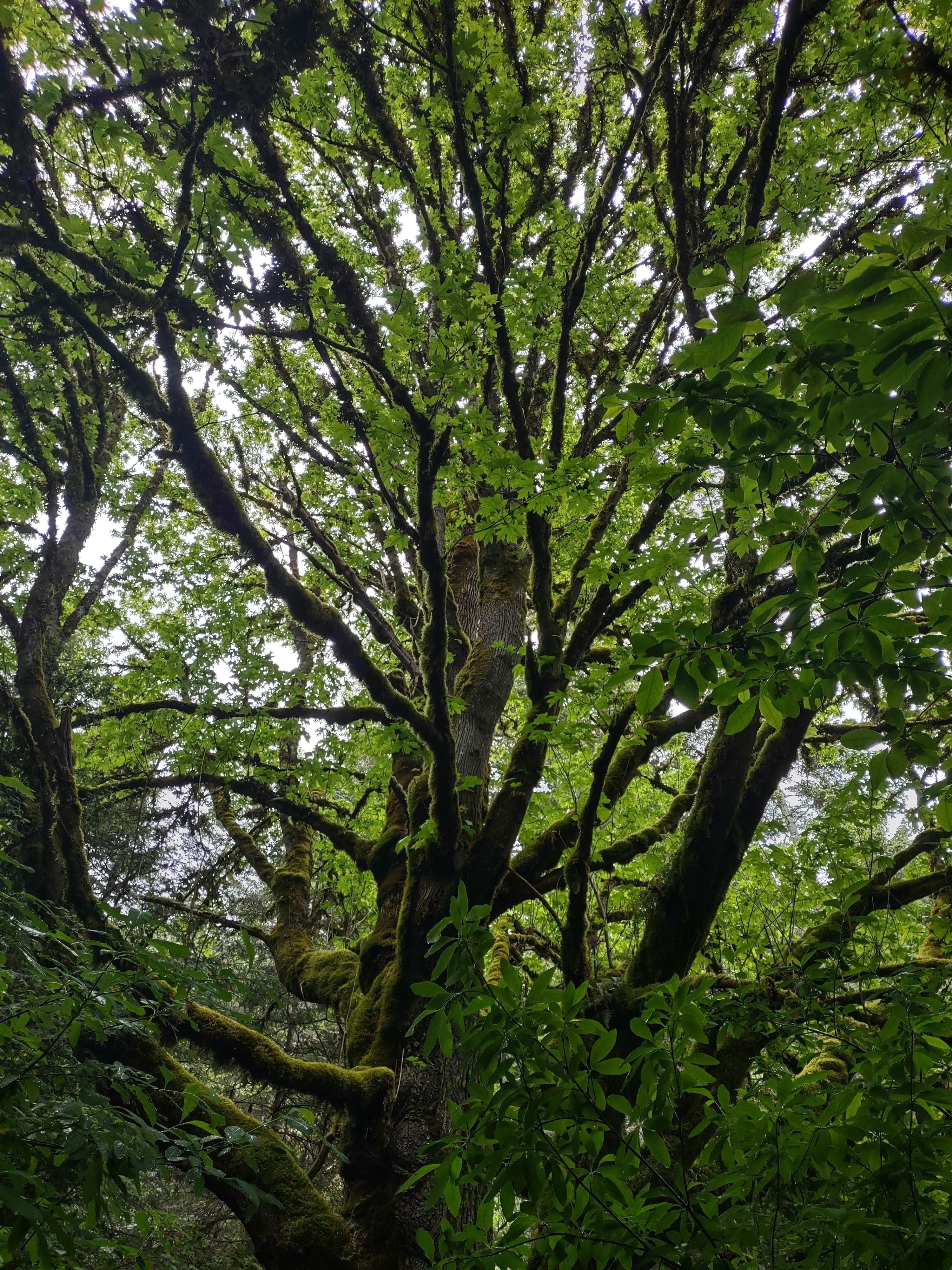
Madison Falls is a short trail, and we were instantly amazed by what at first we could not identify and were barely able to take in, bigleaf maples totally coated with clubmoss and licorice ferns. No one else was there and we were standing in the rain (all with raincoats and hats, no problem), with our mouths hanging open, looking at these majestic trees. And then we walked the short path up to the falls in Madison Creek, gushing 100 feet down moss-covered basalt, and we loved that sight too. We sure saw some more awesome trees, mightier falls, and more cascading rivers later in the trip, but being on a smaller scale, this was a great introduction. Our minds were opened by Madison Falls and we had them to ourselves on that rainy morning.

We began to see a few breaks in the clouds as we got back on 101 West and proceeded to the Sol Duc (sometimes spelled Soleduck) area of the Park. The road wound back and forth, uphill past driveways leading down to houses clustered around the sides of Lake Sutherland, then across a wide strip of glacial moraine, emerging between mountains covered with Douglas fir and western hemlock to wind around the beautiful shores of Lake Crescent, back in the National Park. This glacial lake plunges to over 600 feet, and the water is so free of algae that it glows turquoise around its edges. The lake is home to the Beardslee and Crescenti trout, which are found nowhere else in the world.
We just had to pull over and soak in the view of the lake at the first viewpoint, along with several other cars. We were in awe again, but the driver of the car just before us took the opportunity to try to drag me into conversation. “You know it’s actually two lakes!” he told me, as an opening gambit. He then covered many other topics and found out that we were visiting from exotic Massachusetts and had never been to Washington before. He was awed by that, but it didn’t slow him down. He told me what he thought was some great info, “You know, in Clallam County all the busses are free, so you guys can take a bus into Bainbridge Island and then take a ferry into Seattle. There’s a great farmers’ market there!” I thanked him for the info but we wouldn’t be going into Seattle. He was taken aback, which was all I needed to walk away and look at the view.
The rain had stopped, the clouds were blowing away to the East, and it was becoming a lovely day. Got back in the car and wound farther down the lake, past the Storm King Ranger Station and the Fairholme Campground area, eventually turning left down the Sol Duc Road. We drove several miles down this, past the Sol Duc Hot Springs Resort and Campground, and parked at the Sol Duc Trailhead.

We were going to check out Sol Duc Falls and then do the Lover’s Lane Loop Trail, and so geared up for a long hike. This was a big departure/re-supply point for back-country hiking, and there was a shelter for hikers caught in thunderstorms not far down the trail. There were several people on the first part of the hike down to the falls, but it wasn’t crowded at all, and then there was practically no one on the Lover’s Lane Loop. And this hike was beyond amazing, I don’t know how to begin describing it. Perhaps some pictures would help.

This was old growth, temperate rain forest. We saw lots of specimens of the bigleaf maples, and also Douglas firs, Sitka spruces, red cedars, and western hemlocks; the most impressive trees might have been the fallen ones that had become massive nurse logs, some sprouting and supporting hundred-year old trees themselves. Sword ferns, vine maples, devil’s walking-stick, tiny wildflowers, every variety of moss we’d ever seen and many we hadn’t, lichens, everything draped with clubmoss, mushrooms and fungi, rocks covered with layers of growth, everything alive. We saw just a few flying insects and a few millipedes and spiders, but no other animals that day, just amazing plant life growing everywhere.

We got to the falls themselves after almost a mile, and this was pretty spectacular too. One guidebook we had gives a technical description of how the bedrock tilted to form a narrow channel in the river, but you’ve gotta see it to believe it. There was a heavy stream of mist coming up from the cataract, and it formed a rainbow that we struggled to capture with the camera.
We continued past the falls on to the Lover’s Lane Trail, that wound for 5 or so more miles up along the West side of the river to the campground and then down the East side, back to the parking lot. But after a mile or so we decided to change plans; this would have been a few more hours of the same thing, we only had a few granola bars and bananas and were getting hungry, and we wanted to get back to Hurricane Ridge that day since the weather had turned so nice.

So we reversed, cruised by the falls again and took some more pictures … the sun had moved and lit up a different rainbow over the cataract … and then back up the Sol Duc Trail to the now crowded parking lot. We cruised back up the road looking for a secluded picnic table to make our PB&J sandwiches on, and found a fine one right before the Salmon Cascades site.

Back up to the head of the road and turned right on 101, but before heading straight back to Port Angeles we wanted to check out the Marymere Falls Trail at Lake Crescent, which the Ranger had recommended to us that morning. It was a 45 minute drive back to the Storm King Ranger Station at Lake Crescent, where we parked and followed the path down to the beach, and then started on the Marymere Falls Trail by going through a culvert under route 101.

This was another mile there and mile back, through old growth forest dominated by Douglas fir, which started off flat but then went steeply uphill to a falls in a tributary of Barnes Creek, cascading down off Mt. Storm King, which featured in the Klallam Indians’ origin story of Lakes Crescent and Sutherland (the two lakes). That story is covered in this article, as well as other gruesome tales.
Returned down the same path, filled our water bottles at the Ranger Station, and then continued East past the two lakes for the 30-minute drive to Port Angeles and the Hurricane Ridge entrance to the Park. There we passed the VC we’d been to that morning and shot up and up into the blue sky, surrounded by trees and snow-covered mountains.
We thought we’d done a lot of uphill driving in Great Smoky Mountains NP, over the saddle in Hawaii, and up the Moki Dugway in Utah. But this may have beaten them all, as it climbed and climbed and became twistier and twistier. I’m not a cautious driver, but this was getting a little hairy, especially when there was so much to look at and the drops we were going around were so steep. In 18 miles of serpentine road, we gained 5242 feet. Play the video on this page, which must have been taken right around the time of year we were there.
We finally got to the top and there was a big parking lot, but where was the VC?? We parked near a hole in the ground where it apparently used to be … it had burned down in 2023 and probably isn’t going to be rebuilt any time soon. They were running a gift shop out of a trailer. Again, the NPS needs better support to maintain its Parks for the enjoyment of the people.

But the key thing was, this was an absolutely beautiful place! There was a range of snow-capped mountains right across the deep valley of the Lillian River to the South, and behind us was the ridge itself, partly covered with snow (but with a few trails open), and affording absolutely lovely views off to the North over the Strait to Canada. In fact, Sarah’s phone buzzed and T-Mobile had texted her, “Welcome to Canada!” Another funny thing was the presence of blacktail deer, who were everywhere. They wandered across the parking lot, “innocently” blocking cars, lounged on the steep slopes, and seemed oblivious to the swarming humans.

We set off on one trail through subalpine meadow until it was blocked by deep snow, then circled back around to the High Ridge Loop Trail, up to a summit with bunches of delicate wildflowers growing in the scree as the trail got steeper. At one switchback, Sarah figured she’d gone high enough, but Dave and I continued up almost to the top, where we were blocked by snow again. We saw a large marmot sunning himself across the meadow.

Oh no, our long day of exploring the spectacular Park was drawing to a close, and we were getting pretty tired out, especially after that steep hike. Wandered around a bit more, but then it was back to the car and down and down the road, stopping at a few places to enjoy the view and let the brakes cool off … we could actually smell them.

Time to start thinking about dinner, but first back to the hotel to change out of our smoking boots and get in a little rest. We found a place right down by the dock in the center of Port Angeles, and realized that this was right near the City Pier, which had an observation tower. So we headed down there and it was a sparkling evening, out on the water. The town has its own spit, which forms a long, curving pier that hosts a Coast Guard air station and shelters the harbor. This is the first port for many ships coming across the Pacific into the Salish Sea, and several massive ones were anchored just offshore in a line.

We snapped a few pictures on the dock, and then drove a couple of blocks into the old town, where the restaurant we’d settled on was mobbed and had a 40-minute wait! Oh well, we debated about a Plan B and decided that the thing to do was just go to the restaurant we were parked in front of, the Oak Street Bistro. Strange that the one a few blocks away was mobbed and this one was deserted, but the food was fine, the beer was cold, and the service was mellow but good enough.
Found a gas station on the way back to the hotel, filled up the tank and got a few more bottles of water in their store. We hadn’t gotten enough at the WinCo but now could rotate them and re-fill the empties when/where potable water was available. Back in our suite in the Super 8 we played another game that evening, but ended up going to bed not that late. It had been quite a day!
Sarah took pictures of these wildflowers during that day:
- Broadleaf Lupine
- Kinnikinnick
- Salal
- Western sword fern
- Alumroot
- Vine Maple
- Bigleaf Maple
- Hedge Mustard
- Narrowleaf plantain
- Ox-eye daisy
- Coastal Mugwort
- Licorice Fern
- Western Bunchberry
- Deer's-Foot/Vanilla Leaf
- Devil's walking stick
- Scouler's Corydalis
- Red-berried Elder
- Deer Fern
- two-leaved Solomon's seal/false lily of the valley
- American Fairybells
- Stream Violet
- Pacific Trillium
- Woodland Strawberry
- forget-me-nots
- Herb-robert
- Piggyback plant/Youth-on-Age
- Glacier Lily
- Lanceleaf Springbeauty
- Coast Range Lomatium
- Spreading Phlox
- Coast Paintbrush
- Orange honeysuckle
- Arctic Lupine
- Common Vetch
No comments:
Post a Comment