Saturday, May 31, 2025

Amazing Washington - Rain Forest and Beach

 May 30

Got up on Friday and it was a glorious morning, time to go see more amazing stuff!  I didn’t have one good night’s sleep all vacation, but that wasn’t about to stop me.  We wanted to get on the road quickly that morning, but figured that instead of packing up and then finding a breakfast spot, we should just go to Jazzy Joshua’s again.  Lynne was delighted to see us and hear about our hikes, and the omelets were as huge and the coffee as hot as yesterday.

We were tempted to stop at Madison Falls again, but kept the hammer down and hit the two lakes, where we stopped at the Ranger Station to top up our water.  Continued around 101, the Olympic Highway, towards Beaver where we turned South through the town of Forks (where the Twilight vampire stories were set).  About a half hour after that we turned East on the Upper Hoh Road, along the Hoh River towards the real rain forest.

In the North of the Park we’d experienced some of the temperate rain forest in the Elwha and Sol Duc river basins.  But we hadn’t been far from the rain shadow, the area on the lee side of the mountains where the huge dumps of moisture coming from the Pacific have already been mostly spent.  The West side of the Park experiences much more precipitation, and the trees are even bigger.  We were ready!

But, as we traveled down the Hoh Road, we saw ominous signs from the NPS.  Several warned us that we might have a two-hour wait to get into the rain forest area and we should turn around now if we valued our lives.  Well, we weren’t about to have come all that way just to turn around, and so we continued up the river.  As we did we realized the signs were probably correct at some times of the year, but probably not right now in late May.  The warnings went down from two hours to 90 minutes, 60 minutes, and 30 minutes as we steamed along, and before we knew it we were at the entrance station, and hadn’t hit a backup.

Showed them our pass and cruised into the parking lot, which *was* already pretty full.  We got a spot and hit some vault toilets, but then were all turned around and it took some wandering through the densely overgrown campground area before we could find the tiny, shopworn, and crowded Hoh Rain Forest VC.  But that was fine and there was still plenty of time left in the morning.

There are two smaller trails at Hoh, and a trailhead for the long hike up the upper section of the Hoh River to Blue Glacier on Mt. Olympus.  I should say that we never saw the namesake mountain of the Park the whole time we were in it, which was a small disappointment.  There’s a small path behind the VC which then splits for the two shorter trails.  We turned uphill for the Hall of Mosses Loop Trail.

It was here we first really experienced the quick little Douglas squirrel, which were everywhere.  These look a lot like the red squirrels we get in Maine, but are slightly smaller and have faces and movements more like a rat.  Not really cute, but definitely amusing small animals.  We also saw lots of birds in the rain forest area, including a robin (named Robby) who hopped along in front of us on one trail, guiding us safely along.

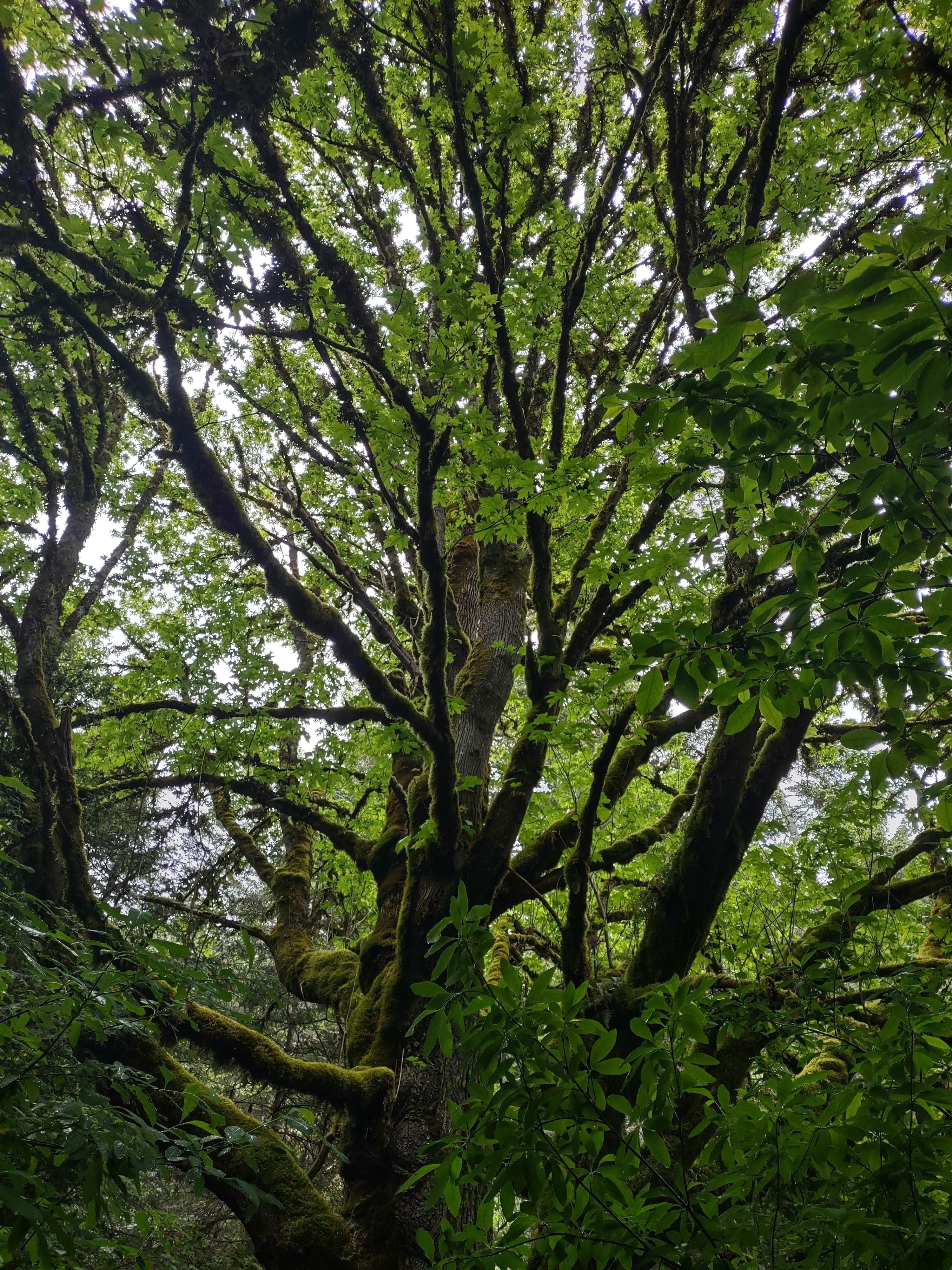
The Hall of Mosses Trail was spectacular.  We thought we’d seen big trees before, but these were even huger, and the oldest were more than 1000 years old.  There were only a few Douglas firs, most were Sitka spruce, which grow amazingly tall, and there were also some western hemlocks and lots of giant red cedars.  But the reason for the name of the trail was the dense grove of bigleaf maples … we thought we’d seen them covered with moss before but these guys were just dripping with pounds and pounds of moss, licorice ferns, and other epiphytes.  There were huge nurse logs that had been feeding the next generation for hundreds of years, and spectacular displays of sword ferns.

Unfortunately, that trail was also filled with hordes of clueless tourists without proper footwear, and many of these were not looking at the trees, they were gabbing loudly about what their cousin said last year, or what kinds of birdfeeders their grandfathers kept.  We were trying to enjoy the trees but this was getting a little oppressive.

Luckily, most of them had turned back or been left behind by the time we got to the next small loop, the Spruce Nature Trail.  This was at a much lower elevation and actually followed the course of the Hoh river for a bit.  And they had the biggest Sitka spruces here, some of them were just unreal, they were so big and so tall.  You’d be walking along and see a massive tree trunk in front of you, tilt your head up and up to look at it, but not see anything but more and more trunk.  You had to actually stop, take your hat off, put your hands on your hips, and tip way back to see even the underside of the massive crown.

At one blessedly silent point of the trail, we came upon a woman who put her finger to her lips and pointed to a solitary cow elk we hadn’t noticed but was standing right near us in the swamp, eating leaves and having a fine time.  Of course, as we left quietly we heard the crowd bumble around the curve of the trail behind us and one of them shouted, “LOOK, AN ELK!!!!”  At least they knew what it was.

And yes, this was mostly a swampy area with some real swamp plants, most of which were new to us but some of which were absolutely gigantic skunk cabbages, also many specimens of a plant somewhere between a fern and a bottle-brush, the horsetail.

Finished both of the short trails, and then set up our food at a secluded picnic table in the overgrown area we’d first seen, for a fine PB&J lunch.  By the time we left, the parking lot was full and they were actually holding up a line of cars at the entry station, letting them in one by one as cars left one by one.

Next, we were headed for the shore.  One of the things we found amazing about Olympic NP was that it has such a variety of impressive scenery, and the beach is one of the best.  We wanted to check out the more Northern beaches in the Park, but this would have taken up almost a full day.  So we went for the more on-our-path Ruby Beach, which was a fine alternative.

We got back onto 101 off the Upper Hoh Road and headed Southwest, across flat miles of more big trees.  Suddenly we were at the edge of the continent, and parked in a half-full lot at Ruby Beach, back in the National Park.  We only had to go a short way down the slanting path before we just had to stop and gape at what we were seeing.  I’d seen pictures of sea stacks, but never had seen one up close, and there they were, extending from the end of the path to the North.

The flora on the shore was dominated by huge bushes of cow parsnip, which were so big they probably had to be cut back regularly so the path wouldn’t be unpassable.  We also saw some delightful towers of foxglove flowers.  We dropped down 100 feet or so to the beach, and it was littered with giant logs washed up by the tide.  We had to clamber over them to get to the beach, they were totally obstructing it.  I walked right up to a sea stack and said hi.  The first picture on this page was taken at Ruby Beach and shows exactly what we saw when we first arrived at the beach, though it was a beautiful, sunny day and not foggy.

Though sunny, there was a strong Northwest wind, the surf was crashing on the shore, and the tide was coming in fast.  One of the attractions of the Washington shore is tide pools, but we’d timed it wrong and the tide was too high to see those.  Before it came in any further, Dave and I hurried right up the beach immediately to see the massive sea stack of Abbey Island just before the tide came in around it.  The surface of the beach was a bad-for-traction mix of round stones and coarse black sand, but we made it up there with some exertion, crossing a tidal inlet on a handy log.

The stacks here were a mix of conglomerate and sedimentary rock, they were just amazing.  The violence of the ocean is not often shown so vividly as in these stacks, which were eroded from the banks on the shore (“a process of coastal geomorphology”), and you can almost feel this process continuing.  Abbey Island is an incredibly high one, with its own forest up 180 feet of vertical walls above the beach.  Dave and I got right up to it, but then turned around quickly and trudged back before we were isolated by the tide.  We saw a seal seemingly playing in the high surf, though it was probably hunting, and I saw a fin of some kind (a dolphin?) in the waves.

We found a slightly easier path back to the ramp to the shore over the giant logs on the beach, and made it back up to the parking lot, where we rejoined Sarah.  Route 101 took us for many more miles down alongside the beach, and we stopped at several overlooks before it swung back Southeast after we crossed the Queets River.

OK, it was getting late in the afternoon and our timing was great for driving the 90 minutes or so to Amanda Park and the Lake Quinault Inn on the North Shore Road at Lake Quinault.  We needed more beer, and the Northshore Grocery (one of those stores that has everything or you don’t need it) was just 20 yards from the hotel and had exactly what we needed.  We checked into our old but totally acceptable room (fine big beds and impressive wood furniture) next to a luxurious rhododendron bush in that small, asymmetric, and worn hotel.  Our neighbors had tattoos and a cute dachshund.  There was no table, but we cleverly set up the suitcase on a stand between the beds so we could wind down with a game of Azul.

We’d scouted where to eat dinner and hurried down to the Salmon House Restaurant in the small village of Quinault itself, because we weren’t sure when they were going to close.  We were pretty much the only ones in the dining room, though there were a lot of people in the lounge when we got there, and there were even more when we left.  This was in a lovely spot on the relatively ritzy South Shore Road, with the lowering sun shining in the windows over the lake and sailboats drawn up on the expansive lawn.  Believe it or not, the menu offered mainly salmon, and Sarah got the dill salmon, I got the blackened salmon, and Dave got the baked salmon.  They were all delicious.

We somehow found out that the “World’s Largest Sitka Spruce” was nearby, and we left the car in the lot while we walked up the road to it after dinner.  It sure was large, really thick and pretty tall (sign said: 58’ 11” circumference, 191’ tall, @1000 years old, 922 American Forest Association points) … we enjoyed it.  Whether it really *is* the largest may be a subject for debate, or maybe not.

We wound around to another path after the tree, back to South Shore Road, and walked slowly back to the car, then drove back to the Inn.  They had tables set up on their lawn, and it was such a lovely evening we took the cribbage board out there and had a fine game.  Some small flying insects tried to bother us, but they weren’t biting and so failed.  We soon retired for the evening, it had been another long day full of wonders!

Sarah took pictures of these wildflowers during that day:

  • Western Sword Fern
  • Candy Flower
  • Horsetail
  • Bracken
  • Woodland Buttercup
  • Threeleaf Foamflower
  • Piggyback plant/Youth-on-Age
  • Candy Flower
  • Trailing Blackberry
  • Pacific Waterleaf
  • Oregon Woodsorrel
  • Cowparsnip
  • Purple Foxglove
  • Seaside Pea
  • Giant Vetch
  • Salmonberry
  • Large-leaved Avens
  • Lady Fern
  • Red Clover
  • White Clover
  • Western Lily of the Valley
  • Red Osier Dogwood


Friday, May 30, 2025

Amazing Washington - Northern Areas of Olympic NP

 May 29

Woke up to overcast skies and a forecast of rain, but clearing later in the day.  While checking out local restaurants the night before, we had come across some mixed references to Jazzy Joshua’s, which was right across the parking lot from us.  So we checked it out for breakfast, if only to save time.  On entering past the Bible display, it was instantly apparent that this restaurant was owned/run by Christians, and one delightful Christian was the only person besides us there that morning, an Asian named Lynne (sp?).  She was eager to talk, but not in a way that would put off Northeasterners, and she was the first person of several we met who were gobsmacked to meet people from exotic Massachusetts.  She confirmed that the area gets much less snow than you might expect, and gave us some great tips on where to hike, actually just reinforcing what we were leaning towards.  And we had a great breakfast there, I had the “Kitchen Stove” omelet, which had everything in it but the … well, you get the picture.

Back to the room for final switching to trail pack mode after that, and then a short trip to the main VC at Olympic NP (which is *in* Port Angeles), arriving about 15 minutes before it opened at 9:00.  We were psyched to explore the Park!  BUT … it was a rainy morning and we huddled under the front awning of the VC, reading signs about road and trail closings, with a volunteer, a young Ranger, and a gathering group of schoolkids on an outing.

The volunteer was talkative, as a lot of Washingtonians turned out to be, and this was great.  We were very disappointed to see from their displays that road access to the first trail we had earmarked was closed because of snow.  The volunteer wanted to recommend others, but when he asked for our itinerary he looked blank when I said we’d be going to Lake Quinault after Port Angeles.

OK, here’s a needed digression.  We come from a world where letters count (some), and European languages at least, are respected.  Some place name pronunciations in Washington did not show respect at first hearing, but that may be my prejudice.  “Sequim” is pronounced “Skwim.”  I pronounced “Lake Quinault” as a French word (“key-NO”) but the regional pronunciation is “kwih-NALT.”  Lynne told us that many Washington place names have silent vowels, and cited Sequim and also the city of Hoquiam, pronounced “HO-kum.”  What do you know?

Anyway, our friend figured out what I meant, and then was busy trying to tell me about his cousin who lived 5 miles East of Boston, and I had to interrupt.  “He must be awful wet then, because 5 miles East of Boston is ocean.”  He was stunned … “So, Boston is *on* the coast?”  Next he asked where Seattle was on our itinerary, and that there was a great farmers’ market there.  I told him that Seattle was not on our itinerary, that we’d be flying straight out after Rainier.  He was sputtering.  Why would you fly to a city and then not go to the city?  But we all were saved by the rushing phalanx of schoolkids and by the opening of the VC.

I bellied right up to the counter and verified with the Ranger that the road to our targeted trailhead was really closed, though she pointed out that we could walk there through several miles of snow if we wanted.  Jeez, and it was raining out and foggy!  Not good weather for tourists, but we huddled and decided to pivot and go West to see Madison Falls and perhaps the Lake Crescent region, saving the socked in heights of Hurricane Ridge for that afternoon or tomorrow.

Great decision as it turned out.  We gathered literature, purchased a t-shirt and hat, inspected their wonderful taxidermy, and piled back into the car and headed West on Park Avenue past the Port Angeles High School, eventually ending up on 101 West, where we put the pedal to the metal (as much as possible through intermittent road construction), past roadsides forests of ferns and invasive weeds out to the Elwha area of Olympic NP.  It was a long sentence.

We hooked hard left on Olympic Hot Springs Road and followed the Elwha River South for a few miles.  This and the other rivers we saw on the Olympic Peninsula are all prime salmon breeding grounds, though swimming up them is quite a feat.  The road was closed beyond the Madison Falls parking lot and trailhead (since 2017 because of a washout … the NPS really needs more funds to maintain what they have), but that’s as far as we were going anyway.


Madison Falls is a short trail, and we were instantly amazed by what at first we could not identify and were barely able to take in, bigleaf maples totally coated with clubmoss and licorice ferns.  No one else was there and we were standing in the rain (all with raincoats and hats, no problem), with our mouths hanging open, looking at these majestic trees.  And then we walked the short path up to the falls in Madison Creek, gushing 100 feet down moss-covered basalt, and we loved that sight too.  We sure saw some more awesome trees, mightier falls, and more cascading rivers later in the trip, but being on a smaller scale, this was a great introduction.  Our minds were opened by Madison Falls and we had them to ourselves on that rainy morning.

We began to see a few breaks in the clouds as we got back on 101 West and proceeded to the Sol Duc (sometimes spelled Soleduck) area of the Park.  The road wound back and forth, uphill past driveways leading down to houses clustered around the sides of Lake Sutherland, then across a wide strip of glacial moraine, emerging between mountains covered with Douglas fir and western hemlock to wind around the beautiful shores of Lake Crescent, back in the National Park.  This glacial lake plunges to over 600 feet, and the water is so free of algae that it glows turquoise around its edges.  The lake is home to the Beardslee and Crescenti trout, which are found nowhere else in the world.

We just had to pull over and soak in the view of the lake at the first viewpoint, along with several other cars.  We were in awe again, but the driver of the car just before us took the opportunity to try to drag me into conversation.  “You know it’s actually two lakes!” he told me, as an opening gambit.  He then covered many other topics and found out that we were visiting from exotic Massachusetts and had never been to Washington before.  He was awed by that, but it didn’t slow him down.  He told me what he thought was some great info, “You know, in Clallam County all the busses are free, so you guys can take a bus into Bainbridge Island and then take a ferry into Seattle.  There’s a great farmers’ market there!”  I thanked him for the info but we wouldn’t be going into Seattle.  He was taken aback, which was all I needed to walk away and look at the view.

The rain had stopped, the clouds were blowing away to the East, and it was becoming a lovely day.  Got back in the car and wound farther down the lake, past the Storm King Ranger Station and the Fairholme Campground area, eventually turning left down the Sol Duc Road.  We drove several miles down this, past the Sol Duc Hot Springs Resort and Campground, and parked at the Sol Duc Trailhead.

We were going to check out Sol Duc Falls and then do the Lover’s Lane Loop Trail, and so geared up for a long hike.  This was a big departure/re-supply point for back-country hiking, and there was a shelter for hikers caught in thunderstorms not far down the trail.  There were several people on the first part of the hike down to the falls, but it wasn’t crowded at all, and then there was practically no one on the Lover’s Lane Loop.  And this hike was beyond amazing, I don’t know how to begin describing it.  Perhaps some pictures would help.

This was old growth, temperate rain forest.  We saw lots of specimens of the bigleaf maples, and also Douglas firs, Sitka spruces, red cedars, and western hemlocks; the most impressive trees might have been the fallen ones that had become massive nurse logs, some sprouting and supporting hundred-year old trees themselves.  Sword ferns, vine maples, devil’s walking-stick, tiny wildflowers, every variety of moss we’d ever seen and many we hadn’t, lichens, everything draped with clubmoss, mushrooms and fungi, rocks covered with layers of growth, everything alive.  We saw just a few flying insects and a few millipedes and spiders, but no other animals that day, just amazing plant life growing everywhere.

We got to the falls themselves after almost a mile, and this was pretty spectacular too.  One guidebook we had gives a technical description of how the bedrock tilted to form a narrow channel in the river, but you’ve gotta see it to believe it.  There was a heavy stream of mist coming up from the cataract, and it formed a rainbow that we struggled to capture with the camera.

We continued past the falls on to the Lover’s Lane Trail, that wound for 5 or so more miles up along the West side of the river to the campground and then down the East side, back to the parking lot.  But after a mile or so we decided to change plans; this would have been a few more hours of the same thing, we only had a few granola bars and bananas and were getting hungry, and we wanted to get back to Hurricane Ridge that day since the weather had turned so nice.


So we reversed, cruised by the falls again and took some more pictures … the sun had moved and lit up a different rainbow over the cataract … and then back up the Sol Duc Trail to the now crowded parking lot.  We cruised back up the road looking for a secluded picnic table to make our PB&J sandwiches on, and found a fine one right before the Salmon Cascades site.

Back up to the head of the road and turned right on 101, but before heading straight back to Port Angeles we wanted to check out the Marymere Falls Trail at Lake Crescent, which the Ranger had recommended to us that morning.  It was a 45 minute drive back to the Storm King Ranger Station at Lake Crescent, where we parked and followed the path down to the beach, and then started on the Marymere Falls Trail by going through a culvert under route 101.

This was another mile there and mile back, through old growth forest dominated by Douglas fir, which started off flat but then went steeply uphill to a falls in a tributary of Barnes Creek, cascading down off Mt. Storm King, which featured in the Klallam Indians’ origin story of Lakes Crescent and Sutherland (the two lakes).  That story is covered in this article, as well as other gruesome tales.

Returned down the same path, filled our water bottles at the Ranger Station, and then continued East past the two lakes for the 30-minute drive to Port Angeles and the Hurricane Ridge entrance to the Park.  There we passed the VC we’d been to that morning and shot up and up into the blue sky, surrounded by trees and snow-covered mountains.

We thought we’d done a lot of uphill driving in Great Smoky Mountains NP, over the saddle in Hawaii, and up the Moki Dugway in Utah.  But this may have beaten them all, as it climbed and climbed and became twistier and twistier.  I’m not a cautious driver, but this was getting a little hairy, especially when there was so much to look at and the drops we were going around were so steep.  In 18 miles of serpentine road, we gained 5242 feet.  Play the video on this page, which must have been taken right around the time of year we were there.

We finally got to the top and there was a big parking lot, but where was the VC??  We parked near a hole in the ground where it apparently used to be … it had burned down in 2023 and probably isn’t going to be rebuilt any time soon.  They were running a gift shop out of a trailer.  Again, the NPS needs better support to maintain its Parks for the enjoyment of the people.

But the key thing was, this was an absolutely beautiful place!  There was a range of snow-capped mountains right across the deep valley of the Lillian River to the South, and behind us was the ridge itself, partly covered with snow (but with a few trails open), and affording absolutely lovely views off to the North over the Strait to Canada.  In fact, Sarah’s phone buzzed and T-Mobile had texted her, “Welcome to Canada!”  Another funny thing was the presence of blacktail deer, who were everywhere.  They wandered across the parking lot, “innocently” blocking cars, lounged on the steep slopes, and seemed oblivious to the swarming humans.

We set off on one trail through subalpine meadow until it was blocked by deep snow, then circled back around to the High Ridge Loop Trail, up to a summit with bunches of delicate wildflowers growing in the scree as the trail got steeper.  At one switchback, Sarah figured she’d gone high enough, but Dave and I continued up almost to the top, where we were blocked by snow again.  We saw a large marmot sunning himself across the meadow.

Oh no, our long day of exploring the spectacular Park was drawing to a close, and we were getting pretty tired out, especially after that steep hike.  Wandered around a bit more, but then it was back to the car and down and down the road, stopping at a few places to enjoy the view and let the brakes cool off … we could actually smell them.

Time to start thinking about dinner, but first back to the hotel to change out of our smoking boots and get in a little rest.  We found a place right down by the dock in the center of Port Angeles, and realized that this was right near the City Pier, which had an observation tower.  So we headed down there and it was a sparkling evening, out on the water.  The town has its own spit, which forms a long, curving pier that hosts a Coast Guard air station and shelters the harbor.  This is the first port for many ships coming across the Pacific into the Salish Sea, and several massive ones were anchored just offshore in a line.

We snapped a few pictures on the dock, and then drove a couple of blocks into the old town, where the restaurant we’d settled on was mobbed and had a 40-minute wait!  Oh well, we debated about a Plan B and decided that the thing to do was just go to the restaurant we were parked in front of, the Oak Street Bistro.  Strange that the one a few blocks away was mobbed and this one was deserted, but the food was fine, the beer was cold, and the service was mellow but good enough.

Found a gas station on the way back to the hotel, filled up the tank and got a few more bottles of water in their store.  We hadn’t gotten enough at the WinCo but now could rotate them and re-fill the empties when/where potable water was available.  Back in our suite in the Super 8 we played another game that evening, but ended up going to bed not that late.  It had been quite a day!

Sarah took pictures of these wildflowers during that day:

  • Broadleaf Lupine
  • Kinnikinnick
  • Salal
  • Western sword fern
  • Alumroot
  • Vine Maple
  • Bigleaf Maple
  • Hedge Mustard
  • Narrowleaf plantain
  • Ox-eye daisy
  • Coastal Mugwort
  • Licorice Fern
  • Western Bunchberry
  • Deer's-Foot/Vanilla Leaf 
  • Devil's walking stick 
  • Scouler's Corydalis
  • Red-berried Elder
  • Deer Fern
  • two-leaved Solomon's seal/false lily of the valley
  • American Fairybells
  • Stream Violet
  • Pacific Trillium
  • Woodland Strawberry
  • forget-me-nots
  • Herb-robert
  • Piggyback plant/Youth-on-Age
  • Glacier Lily
  • Lanceleaf Springbeauty
  • Coast Range Lomatium
  • Spreading Phlox
  • Coast Paintbrush
  • Orange honeysuckle
  • Arctic Lupine
  • Common Vetch


Thursday, May 29, 2025

Amazing Washington - Arrival and Dungeness Spit

 May 28

We’d wanted to travel to the Pacific Northwest for years, we’d never been anywhere near there and were sure we’d love it.  Dave wanted to come too and that was great with us.  So I researched hikes and made reservations.  We wanted to minimize time away from the kitties and so only scheduled a 6-day trip, and only to Washington.  But it was just fantastic and maybe we should have stayed a bit more.

Dave came up on Tuesday and we finalized packing, including one shared suitcase which we’d check.  We were flying Alaska Airlines and they charged for everything, so we were carrying on most stuff.  We also ordered food from them to be served on the flight, which wasn’t an outrageous rip-off.

Woke up really early on Wednesday, May 28, said goodbye to the cats (Andrew would be checking on them), and the Woburn Cab driver with the town car and the handlebar mustache drove us into Logan, a surprisingly painless drive.  Checking the bag and going through security was surprisingly painless too, though everything in an airport is a hassle.  Logan was already overrun at that time of early morning with tweens and teenagers going on field trips or maybe just hanging out and taking up space and quiet.

We found a Not Your Average Joe’s that was serving breakfast and had a leisurely meal, then found our way to the crowded gate, past the pet relief area.  We were just able to get seats together in the gate area, and had a nice conversation with a woman from Waldoboro ME, who was moving to Washington with her cat, Frankie.  Luckily, they announced that they were going to run short on overhead space and so were offering free checking of carry-ons, which we jumped at.

We had seats together and finally boarded the full plane, which left the gate pretty much on time at 9:00AM.  Sarah had the window and Dave had the middle.  I actually got in some snooze time (which I needed), the meal/snack we had ordered wasn’t that bad, and the jet stream was giving us West-bound travelers a break that day, so we were ahead of schedule.  They offered free movies if you hooked up your phone to the on-board wifi and watched on the small screen with headphones.  I read instead and snoozed and played cribbage on my phone.

It was pretty clear weather that day and Sarah had fun watching out the window.  Mostly cities and farms across mid-America, but then the badlands and the mountains started as we crossed the Dakotas and Montana, and we had fabulous views of Glacier NP.  Then civilization started up again and we landed in Seattle.  And we were instantly delighted.  We flatlanders were kind of ready for it, but were just amazed to be able to see snow-capped mountains in several directions from the airport itself, though it was a hot day in the city.

Picked up our checked bags (Alaska Airlines gets good grades, including their commitment to get checked bags out on the carousel quickly), found the shuttle to the car rental, and waited in line at Thrifty’s, eventually getting a black Chevrolet Trailblazer with just 532 miles on the odometer.  We’d originally reserved a compact but had to switch to something else because they ran out of compacts, so chose a small SUV, which ended up costing us less money and working fine.  The Trailblazer had a good amount of room for us three and odd luggage/food/maps/shoes/etc., got good mileage, and didn’t ever blink at the mountain/rugged roads we put it through.  We named her “Muddy.”

Left the car rental place and headed East on Washington 518 and then South on Interstate 5 along with a shocking amount of other cars, the road swelled to five lanes at times.  Luckily the left-hand lane was a (free) HOV lane and we could zip along, down to Washington 16 in Tacoma, where we headed West and then North over the Tacoma Narrows Bridge.  The Interstate had been as urban an experience as you might expect, but as we crossed the bridge we were knocked over again by the beauty of the mountains off to our left and dead ahead, and the blue, lovely, open stretch of water we were crossing.

In Bremerton, 16 turned into route 3, and we exited on route 310 for some shopping.  First was an employee-owned, huge WinCo Foods supermarket … quite the warehouse but we managed to get our small travel supply of PB&J makings, bananas, chips, beer, cider, water, granola bars, and bug spray and sunscreen.  Then down the street to The Novel Tree for some gummies.  Then back on the road to the North.

We were a little disappointed to not get many glimpses of the spectacular coastline we were driving up, but the suburbs, marinas, naval stations, and factories eventually petered out and we tourists were delighted by such prosaic things as the wildflowers and weeds growing on the sides of the road.  We were surrounded by banks of ferns and grasses, incredible carpets of ox-eye daisies, and sudden explosions of yellow bushes, which we determined were a mix of exotic Scotch broom and gorse, but were beautiful.

Route 3 turned into route 104, crossed another arm of Puget Sound on the Hood Canal Floating Bridge, and continued out West as route 101, which we’d be on for a while; we followed it in our circumnavigation of the Olympic Peninsula.  Our destination was the Dungeness Recreation Area and National Wildlife Refuge in Sequim, a short drive North on Kitchen-Dick Road through farms that looked like they never saw snow (even though snow-covered mountains were looming in our rear-view) and more spectacular fields of daisies.

We pulled up to the end of Voice of America Road (guess they have to broadcast across the Strait to the Canadiens to protect Democracy??) into a small parking lot.  We finally emerged from the car, ready to start our adventures, and were immediately knocked over by the blasting West-Northwest wind, though there was still a berm between us and the water.  We put on extra layers, tightened the straps on our hats, and set off down the seaside path through the Recreation Area up the shore towards the NWR.

Some setting of the scene may be in order here.  Between Washington and British Columbia is a huge arm of the sea called the Juan de Fuca Strait (part of the Salish Sea, that extends up into Canada).  The prevailing Northwest wind blows sand down the strait and has made spits on the Washington coast, such as the Dungeness spit.  We were up on the bluff, hiking beside clusters of beach roses (native Nootka roses), ferns, the ubiquitous salmonberry bush, and plants we’d never seen before, stopping at viewpoints to gawk down at the turbulent sea and across the @15 miles of brilliantly lit water to Vancouver Island, and being blasted at times by the sand, though we were high above the beach.


It was about half a mile, past the campground, to the entrance to the NWR, where they have a nice kiosk and bathrooms, and we had a short conversation with a volunteer who answered some of our amazed questions and checked my America the Beautiful pass.  The path then took us downhill past huge trees to the start of the spit itself, and I have no idea how to describe how it was so immediate, was all I’d imagined, but was more.  The wind was blasting us, the waves were threatening us, large seabirds struggled with the wind, the driftwood logs that had washed up on shore were massive, the sun was beating down, and the spit extended out and out into the sea with the faint mass of Mt. Baker seemingly hovering over the lighthouse out at the end of the 5-mile spit.  Our cameras had no hope of capturing what it was like.


We walked around the sea side and the bay side of the spit a bit, but would have been foolish to venture down it, even though it would have been glorious.  Well, glorious on the way there but impossible on the way back, with the wind and the driven sand in our faces.  The accumulating sand actually adds 18 feet to the spit every year.  We soaked in as much as we could, this was a great start to our vacation!  But it was already getting near 9:00PM by our body clocks, and the restaurants we’d researched in our destination of Port Angeles all closed at 8:00.


Walked back up the path from the spit and detoured on the Primitive Trail to get back to the kiosk, rather than the straight trail we’d just been down.  Back to the car, and it was just another half hour drive down local roads to 101 and into Port Angeles.  Port Angeles is a funny town, nestled between the towering mountains of Olympic NP to the South and the wild Juan de Fuca Strait to the North.  It’s a bit of a port town, a bit of an artsy town, and has a mix of nice houses and lots of run down ones, between straight streets of strip malls and auto repair shops.

We headed past the hotel we were going to stay at and into the “downtown” area, to the Midtown Public House, which is a really fun little brewpub disguised as an Asian fusion restaurant (or vice versa).  I had a fantastic bowl of udon noodles and pork belly, but was too tired to finish it.  Sarah and Dave were getting pretty tired too by that time.  We headed back up the road to the Super 8 by Wyndham Port Angeles and were assigned a nice, quiet, small 2-room suite on the third floor (only 28 steps up) from which you could just see a mountain if you peeked around the corner.  We dragged everything upstairs, stowed it all, played a quick game of our take on 3-person cribbage, and then I went to bed … who knows what the others did.

Sarah took pictures of these wildflowers during that day:

  • Scottish Broom
  • Gorse
  • Smith's Cress
  • Nootka rose
  • orange honeysuckle
  • salal
  • Baldhip Rose
  • trailing blackberry
  • Lawn daisy
  • Western Starflower
  • Threeleaf Foamflower